DIGITAL HISTORY ATLAS · An independent source-led atlas; reconstructed boundaries and disputed attributions are labelled.Central Asia · 500–800 CE
An independent historical atlas · Historical research

THE SILK ROADS
Through Central Asia

500—800 CE
Evidence, landscapes, lives
From the oasis markets of Sogdiana to the courts of China and Byzantium: how Central Asia connected economies.

A trade-first interactive history, c. 500–800 CE. Explore who moved goods, where merchants lived, which cities mattered—and what the surviving evidence cannot tell us.

01 / Explore the atlas

A landscape
through time.

Names on the map identify dated research reconstructions. Click any outline, site, or regional focus label to open a local dossier; choose a year to see the model change. Ancient regions are not modern countries.

—
Cliopatria · Research model
◉ Labels and outlines are research interpretations · Regional anchors are modern archaeological locators
Year · Common Era
650 CE
500550600650700750800
Research models change by dated intervals, not annually.

Move the slider or press Play. Click any highlighted site or outline to open an atlas dossier that can also jump to the full local card below.

Dated political models in this view · Click a name to open its atlas card
02 / THE COMMERCE BEHIND THE SILK ROADSTRADING SYSTEMS · CENTRAL ASIA · 500–800 CE
A commercial world, not a single road

Goods moved. People connected the world.

The famous Silk Roads were not one caravan highway from China to Europe. They were overlapping networks of oasis towns, steppe routes, merchants, households, courts and local markets.

Between the fifth and eighth centuries, Sogdian merchants from the Zerafshan region became exceptionally important intermediaries in Eurasian overland trade. Samarkand and Bukhara supplied urban bases; communities scattered across the routes provided commercial relationships and local knowledge. The value of Central Asia lay not only in location, but in the people and institutions able to make exchanges work.

Chinese silk, horses, furs, musk, precious metalwork and other goods circulated through multiple hands. A vessel found in a distant tomb may record exchange, tribute, a gift or a later journey—we cannot automatically tell which.

Explore the full trade research dossier →
How do we picture a caravan? This is a seventh-century artistic model, not a photograph of a real caravan. Objects like this show how mobility was imagined and celebrated in Tang China.
WHY THE OASES?

Water, farms, markets, workshops and political contacts made connected settlements possible.

WHAT CROSSED THEM?

Silk and woven goods, animals, metals, aromatics, art and information—not always all on the same journey.

WHO BENEFITED?

Merchants, transporters, rulers and craftspeople could gain, while risks, tolls and unequal power shaped exchange.

WHAT CAN WE COUNT?

No defensible total Eurasian trade turnover or city-level annual profit for 500–800 CE.

568 CEWESTWARD CONNECTION / DIPLOMACY & SILKWhy did Sogdian merchants approach Byzantium?A documented commercial mission, but no surviving sales ledger

Silk was political. Access to markets was negotiated.

The sixth-century historian Menander Protector preserves an episode in which Sogdian commercial interests, working with the Türk rulers, sought western markets for silk. After tensions involving the Sasanian Empire, an embassy reached the Byzantine court in 568. The Sogdian Maniakh is associated with this diplomatic-commercial initiative.

The historical point is significant: Central Asian intermediaries were active participants in negotiating market access. Yet no document establishes the revenue of a Sogdian firm, an agreed commodity price or total Byzantium–Central Asia turnover from this mission.

What this means for Europe: the Byzantine Empire was an eastern Mediterranean state. The modern European Union did not exist. This is evidence for a link to Byzantine markets, not a statistical claim about present-day EU trade.

Source: Étienne de la Vaissière, “Sogdian Trade,” Encyclopaedia Iranica ↗, section “Expansion and apogee,” citing Menander Protector.

Solidus of Justin II with Tiberius II ConstantineByzantine coinage gives material context for the empire involved. This particular coin is not known to have passed through Central Asia.Comparison only: not a proof of the 568 embassy.
Silk textile fragment, seventh–eighth centuriesSilk textile material illuminates what made the commodity valuable. This fragment is not a shipment from Maniakh’s embassy.Object attribution to Sogdiana requires a catalogue check.
OPEN THE RECORD / FOLLOW THE EVIDENCE

What can we actually measure?

Each number below has a specific source—and a limit. Tap to see what historians can and cannot infer.

01 / A CUSTOMS REGISTER29 of 35Recorded transactions involved Sogdian merchantsTurfan region, early seventh century · Show documentary context+

Étienne de la Vaissière describes a fragmentary customs register from the Gaochang/Turfan region, probably c. 610–620. Of its 35 recorded transactions, 29 involved Sogdian merchants; another scholarly discussion notes that in 13 cases both parties were Sogdian. These are only the transactions in this preserved fragment, not 83% of all Silk Roads trade.

Sogdian-language contract, 639 CEA Sogdian-language contract dated 639 CE illustrates the type of commercial documentation that survives. It is a different document, not the Turfan customs register.The contract concerns enslavement—a reminder that exchange also involved coercion and human suffering.
Source · de la Vaissière, Eastern Iranian Migrations to China, Iranica ↗
02 / A COMPARATIVE PRICE≈ 2×The price of silk farther westDunhuang → Samarkand, first half of the eighth century · Open method+

By comparing dispersed documentary evidence, de la Vaissière concludes that the price of silk transported by Sogdians roughly doubled between Dunhuang and Samarkand in the first half of the eighth century. A price difference is not the same as net profit: feed, transport, political payments, risks and partners all had costs.

Figured silk with birdsPatterned silk illustrates high-value textile production, but this specific fragment is not part of the price calculation.Provenance and museum dating require an individual record check.
Source · de la Vaissière, “Sogdian Trade,” Iranica ↗
03 / A LIMIT OF THE ARCHIVEUnknownTotal annual trade, taxes and merchant profitWhy the missing statistics matter · Open the reasoning+

No continuous series of annual exports, imports, customs revenues, GDP or city profits survives for the region in 500–800 CE. Coins and objects show circulation, craft production or political authority; they rarely identify the complete chain of ownership or transaction value.

Samarkand / Varkhuman coinA Samarkand ruler’s coin helps tell a story about local authority and money. It cannot measure the city’s total annual trade.Attributed by the supplied title to Varkhuman, c. 650–675 CE.
Source · de la Vaissière, “Sogdian Trade,” Iranica ↗
03 / FOLLOW A SOGDIAN MERCHANTSELECT A CITY · CHOOSE GOODS · FOLLOW A NETWORK · TEST AN EXCHANGE
A CHOOSE-YOUR-ROUTE TRADE EXPERIENCE · EVIDENCE LED

Follow a Sogdian merchant.

Make decisions as a hypothetical Central Asian merchant: choose a home oasis, select a documented kind of trade good, explore an eastern or western network, and see what the sources can—and cannot—tell us about an exchange. This is a scenario, not a claim about one recorded journey.
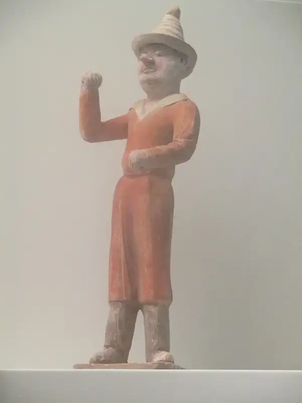
Tang-period figure conventionally identified as a Sogdian trader
Artistic representation from Tang China—not a portrait of our imaginary guide.
01 · Begin02 · Cargo03 · Routes04 · Exchange05 · Return
YOUR STARTING POINT

A merchant’s story begins in an oasis.

Choose Samarkand or Bukhara on this schematic. The routes describe documented network connections—not the verified itinerary of one person.

ByzantiumSamarkandBukharaFerghanaDunhuangChang’an
SCHEMATIC NETWORK / NOT A GPS TRACK OR A SINGLE MERCHANT’S ACTUAL ROUTE
WHAT THIS IS / IS NOT

Our fictional decisions are for learning only. Any exchange shown here is a scenario, not proof that an individual reached that destination or earned the revenue. Real object dates, written sources, uncertain routes and the absence of surviving profit records remain visible throughout.

Historical transparency: dashed polygons are sourced, approximate Cliopatria reconstructions under scholarly review, never exact national borders.Base geography is a schematic coordinate grid, not a modern web map · Runs offline.
04 / COMMERCIAL GEOGRAPHY

Ten places, different economic roles.

Read their role in exchange first; then open local history, surviving buildings, archaeological plans and cited research. Cities are not interchangeable, and none is a modern nation-state.
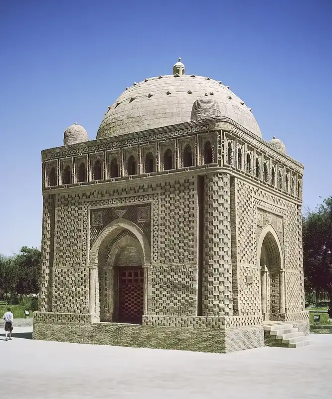
An exceptionally preserved example of later brick architecture in Bukhara.
LATER COMPARISON
02 / Core Central Asia

Bukhara

Life along the lower Zarafshan

WHY IT MATTERED An oasis economy connecting irrigated land, towns and distant merchants.

READ THE FULL STORY HERE
DIGITAL HISTORY ATLAS · HISTORY, SOCIETY & EVIDENCE
TRADE FIRST / oasis economy and regional exchange

A fertile oasis could sustain a trading world

Bukhara was not a single caravan stop surrounded by emptiness: it belonged to a densely settled, irrigated oasis with fields, craftsmen, fortified quarters and nearby commercial towns. Together, Bukhara and Paykend illustrate the productive home base behind Sogdian long-distance traders.

Coins linked to local rulers help trace regional authority; they do not tell us what an individual buyer paid. Varakhsha, associated with the Bukhara ruling elite, provides a different window onto the wealth and cultural connections of the oasis.

Historical setting

Lower Zarafshan oasis

Political organisation

Local Bukhara rulers and elites are attested, but the relationship between urban authority and outside powers changed during the period.

Silk Roads significance

Its irrigation landscape, fortified settlements, craft production and trade linked the lower Zarafshan to wider networks.

Evidence & limits

UNESCO III, pp. 237–246; de la Vaissière, pp. 104–106. Avoid treating the modern city as the ancient polity.

THE BUILT WORLD / RUINS, PLANS AND SURVIVALS

What did this place look like?

The excavated and described early medieval city had walled sections that changed through time. Photographs of the Ark today and the Samanid Mausoleum are useful for comparing layers of Bukhara’s built heritage, but their surviving visible fabric is later than 800 CE.

OBJECTS · ARCHITECTURE · CONTEXT

Architecture, craftsmanship & evidence

These are distinct types of evidence. Reconstructed plans and later buildings are marked as such; no reconstruction is passed off as a surviving seventh-century photograph.

VISUAL EVIDENCE / 3 ORIGINAL FILES

Photographs and object images from the research archive. Select an image to examine it more closely without leaving this dossier.

A city shaped by the lower Zarafshan

Early medieval Bukhara formed part of the irrigated landscape of the lower Zarafshan. Its history cannot be compressed into a single foundation date. Archaeological evidence cited by Pugachenkova and Rtveladze reaches considerably earlier than the fifth century CE, while Richard Frye cautions that the securely traceable history of the city is far more limited. These statements concern different kinds of evidence: occupation levels are not the same as a continuous written history. [CL-076, CL-091]

Walls, streets and urban growth

Archaeological reconstructions describe Bukhara's fifth- and sixth-century shahrestan as two separate walled sectors, divided by an old riverbed that functioned as a defensive ditch. The sectors gradually joined by the opening decades of the eighth century; the former ditch became a principal street. The resulting fortified city has been estimated at approximately 30–35 hectares, while the UNESCO synthesis gives approximately 34 hectares excluding the citadel. These are scholarly estimates, not a ready-made georeferenced outline. [CL-077, CL-078, CL-079]

The citadel followed its own building history. One archaeological synthesis tentatively associates substantial rebuilding with the rule of the Bukhar-khudat Bidun in the later seventh century. The attribution is explicitly uncertain and should not be converted into a precise reconstruction for one year. [CL-080]

Water and the land beyond the walls

Irrigation was fundamental to the Bukhara oasis. Étienne de la Vaissière summarizes evidence that the irrigated western margin advanced during the sixth century, giving an estimate of around 22 kilometres. He also discusses a very large protective wall around the oasis, which may date to the end of the fifth century. Neither statement establishes an exact political frontier: irrigated farmland, defensive walls and jurisdiction are distinct geographic layers. [CL-081, CL-082]

A connected economy

The archaeological and documentary record of Sogdiana includes cast bronze coins and silver drachms. The UNESCO volume describes issues using titles associated with the rulers of Bukhara, offering one way to study power and circulation without assuming that all trade belonged to one single institution. [CL-083]

Bukhara's development was part of a wider network of urban centres in the lower Zarafshan valley. Nearby Paykend had its own fortifications and economic history. Their relationship should be described as a changing regional landscape, not as a single fixed map of sovereign states. [CL-093]

Research notes

  • Dating caution: no verified polygon has yet been prepared for the fifth-, sixth- or eighth-century town.
  • Evidence distinction: the early archaeological layers and the city's traceable written history are not equivalent.
  • Visuals: a photograph of modern Bukhara or the extant Ark must not be presented as a reconstructed sixth-century building.
  • Publication: historical interpretation; bibliography and image attribution notes are provided below.

Sources and locators

  1. SRC-007: Galina A. Pugachenkova and Edvard V. Rtveladze, “Bukhara v. Archaeology and Monuments,” Encyclopaedia Iranica, paragraphs on early archaeology, the citadel, and the fifth–eighth-century shahrestan. https://www.iranicaonline.org/articles/bukhara-v/
  2. SRC-001: B. A. Litvinsky et al. (eds.), History of Civilizations of Central Asia, vol. III (UNESCO, 1996), chapter 10 by B. I. Marshak and N. N. Negmatov, pp. 243–244. https://unesdoc.unesco.org/ark:/48223/pf0000104612_eng
  3. SRC-003: Étienne de la Vaissière, Sogdian Traders: A History (Brill, 2005), pp. 104–105 (supplied PDF pp. 120–121). https://brill.com/display/title/8359
  4. SRC-011: Richard N. Frye, “Bukhara i. In Pre-Islamic Times,” Encyclopaedia Iranica, opening section. https://www.iranicaonline.org/articles/bukhara-i/
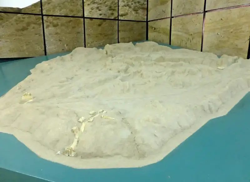
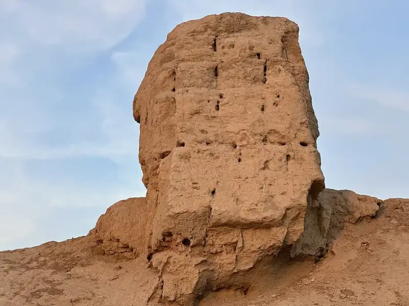
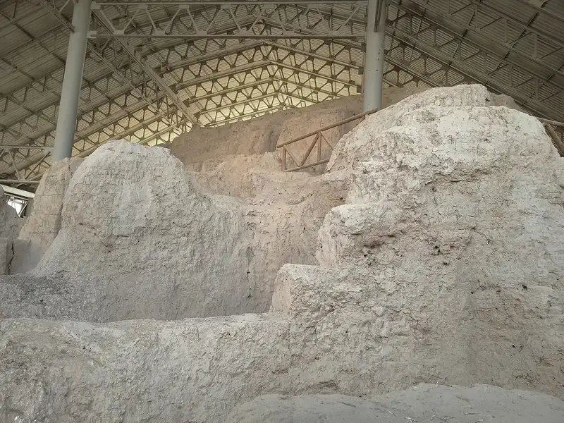
Excavated architectural remains at Paykend.
ARCHAEOLOGICAL / MUSEUM EVIDENCE
03 / Core Central Asia

Paykend

Markets and fortifications at the oasis edge

WHY IT MATTERED An oasis-edge town associated with movement, storage and exchange.

READ THE FULL STORY HERE
DIGITAL HISTORY ATLAS · HISTORY, SOCIETY & EVIDENCE
TRADE FIRST / an oasis-border merchant town

Where the cultivated oasis met the open routes

Near the southwestern margin of the Bukhara oasis, Paykend connected local production with journeys toward the Amu Darya and beyond. Its urban walls, streets and excavated quarters show the infrastructure that made a town useful to people moving goods and information.

Historical narratives about Paykend’s conquest describe wealthy merchants and captured riches. Such accounts are not audited accounts: the impressive sums recorded by later authors cannot be turned into annual sales, municipal income or a caravan-profit estimate.

ADDITIONAL MATERIAL EVIDENCE

Look closer: what survives?

These are dated or attributed objects and present-day archaeological views. None is presented as proof of a particular sale.

Decorated fork from PaykendA small object from Paykend helps connect archaeology to daily consumption.Object attribution as provided; not evidence of an export transaction.
Historical setting

Fortified town near Bukhara

Political organisation

Excavated walls and the urban layout are clearer than the exact institutions of local rule in every century.

Silk Roads significance

Its position at the oasis edge made it significant for exchange, settlement and the movement of people.

Evidence & limits

de la Vaissière, p. 106; UNESCO III, pp. 243–245. Later caravanserais must not be backdated to the sixth century.

THE BUILT WORLD / RUINS, PLANS AND SURVIVALS

What did this place look like?

Archaeologists document a fortified town, citadel and successive urban quarters. The site photographs and its published topographic plan show what survives and what has been measured—not a complete image of the city in any single year.

See the seven original site images and topographic plan in the gallery immediately below. The structures belong to different periods of occupation.

VISUAL EVIDENCE / 7 ORIGINAL FILES

Photographs and object images from the research archive. Select an image to examine it more closely without leaving this dossier.

Where the oasis meets the desert

Paykend (also written Paikand, Paikent, or Baykand in different sources) lies near the southwestern edge of the Bukhara oasis, in the lower Zarafshan region. Archaeological publications identify it as an important urban site linked to routes that connected the oasis with the Amu Darya crossing and regions beyond. This geographic setting should not be turned into a precisely drawn ancient caravan route until an appropriate historical cartographic source is reviewed. [CL-086]

The early medieval town

Étienne de la Vaissière places Paykend among the planned urban centres that expanded in Sogdiana in the fifth and sixth centuries. His summary describes a roughly square outer wall measuring approximately 330 metres on each side, enclosing about 11 hectares close to an older citadel. These measurements convey scale, not a georeferenced shape for a particular year. The exact construction phases remain to be checked against excavation reports. [CL-084, CL-085]

The archaeology of Paykend is the product of sustained work. An overview published in Vostok (Oriens) records systematic excavation by the Bukhara Archaeological Expedition from 1981 onward and examination of the citadel, urban quarters, streets, water systems and areas of commerce. These structures belong to different occupation phases. They cannot all be shown simultaneously on a map dated 600 or 700 CE. [CL-087]

Conquest and written memory

Arabic and Persian historical narratives place Qutayba ibn Muslim's campaign against Paykend around 705–706 CE. De la Vaissière examines these accounts as sources for the town's commercial history and warns against reading the figures for captured wealth as straightforward economic statistics. The story recorded by Narshakhi of merchants returning and rebuilding Paykend after its capture is evidence for how the town was remembered in a later narrative; it has not yet been independently verified here as an archaeological reconstruction. [CL-088, CL-089, CL-092]

What belongs on the timeline?

Paykend remained occupied well beyond our atlas's core period. In particular, an open-access archaeobotanical study of a rabat focuses largely on the Qarakhanid era, approximately 999–1211 CE. Such findings are valuable for Paykend's later history but must not be used as visual evidence for the sixth, seventh or eighth century. [CL-090]

Research notes

  • No route polyline: the sources describe trade links, but we do not yet have a verified historical route geometry.
  • No exact city wall polygon: an approximate 11-hectare enclosure is not permission to draw a square on today's basemap.
  • Narrative caution: the c. 705–706 event requires source criticism and careful dating.
  • Image caution: later caravanserais are not illustrations of a sixth-century trading town.
  • Publication: historical interpretation; bibliography and image attribution notes are provided below.

Sources and locators

  1. SRC-003: Étienne de la Vaissière, Sogdian Traders: A History (Brill, 2005), pp. 105–106 (supplied PDF pp. 121–122); pp. 268–269 (PDF pp. 292–293). https://brill.com/display/title/8359
  2. SRC-008: Andrey V. Omelchenko, “Researches of the Bukhara Archaeological Expedition in Paikend,” Vostok (Oriens) 2019, no. 6, DOI 10.31857/S086919080007750-2. Only the accessible abstract checked here. https://vostokoriens.ru/articles/issledovaniya-bukharskoy-arkheologicheskoy-ekspeditsii-v-paykende/
  3. SRC-009: Mark Luce, “Khorasan iii. Historical Geography in the Late Sasanid–Early Islamic Periods,” Encyclopaedia Iranica, section “Sogdia.” https://www.iranicaonline.org/articles/khorasan-iii-historical-geography-in-the-late-sasanid-early-islamic-periods/
  4. SRC-010: Mir-Makhamad et al., “Qarakhanids on the Edge of the Bukhara Oasis: Archaeobotany of Medieval Paykend,” Economic Botany 75 (2021), 195–214, DOI 10.1007/s12231-021-09531-6. Later medieval context; outside our 500–800 CE focus. https://doi.org/10.1007/s12231-021-09531-6
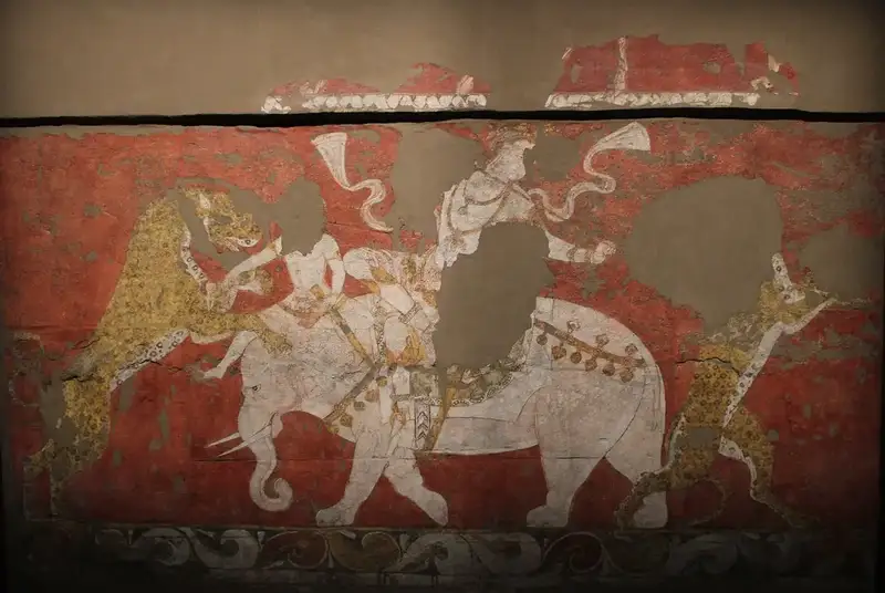
A detail of the painted elephant / royal figure motif at Varakhsha.
ARCHAEOLOGICAL / MUSEUM EVIDENCE
04 / Core Central Asia

Varakhsha

A palace and its extraordinary murals

WHY IT MATTERED A courtly and craft centre in the network of the Bukhara oasis.

READ THE FULL STORY HERE
DIGITAL HISTORY ATLAS · HISTORY, SOCIETY & EVIDENCE
TRADE FIRST / a palatial node in the Bukhara oasis

Trade wealth is not always found in a marketplace

Varakhsha was associated with the rulers of the Bukhara oasis and occupied a strategic frontier between cultivated lands and steppe contacts. The surviving palace decoration is evidence of commissions, elite consumption, skilled labour and a wide repertoire of artistic motifs.

Its famous elephant scene should not be mistaken for proof that live elephants were traded here. Imagery can travel through patronage, stories and objects. The site’s trade significance is regional and contextual, not a known balance sheet of imports and exports.

Historical setting

Palace complex of the Bukhara oasis

Political organisation

The site is associated with the ruling milieu of Bukhara; a palace is not a separate state with its own invented borders.

Silk Roads significance

Courtly wall paintings and architectural decoration show the creativity and cultural connections of the Sogdian elite.

Evidence & limits

UNESCO III, pp. 244–248. The painted halls and their religious iconography have disputed interpretations.

THE BUILT WORLD / RUINS, PLANS AND SURVIVALS

What did this place look like?

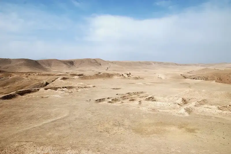
The fortified palace was built, altered and redecorated through successive phases. Its “Red Hall” murals survive as fragments, while the ruined mud-brick buildings are photographed in their present condition.

OBJECTS · ARCHITECTURE · CONTEXT

Architecture, craftsmanship & evidence

These are distinct types of evidence. Reconstructed plans and later buildings are marked as such; no reconstruction is passed off as a surviving seventh-century photograph.

VISUAL EVIDENCE / 7 ORIGINAL FILES

Photographs and object images from the research archive. Select an image to examine it more closely without leaving this dossier.

Landscape and mural must not be confused: this modern view documents the archaeological site. It is not a photograph of the Red Hall paintings. The palace programme and iconography need separate archaeological and art-historical interpretation. UNESCO Vol. III, pp.244–248.

A palace in the Bukhara oasis

On the margins of the Bukhara oasis, Varakhsha preserves the remains of a fortified palace complex associated with the rulers of Bukhara Sogd. Its setting links the history of an oasis residence to the wider Sogdian world of towns, cultivated fields, and connections to the steppe. The historical identity of this site should not be converted into a political border on the atlas. [CL-094; SRC-012; SRC-015]

Discovery and reconstruction

Archaeological excavations began under Vasilii Shishkin in 1937–38, with major postwar work continuing into the 1950s. Scholars have since compared the physical remains with coins and medieval narratives. Aleksandr Naymark's proposed sequence of five building phases extends from the late seventh to the later eighth century, but this is a scholarly reconstruction rather than five ready-made, accurately georeferenced plans. [CL-102; CL-103; SRC-013]

The Red Hall: a painted confrontation

The palace's Red Hall takes its name from its vivid painted background. A surviving main frieze depicts a figure on an elephant confronting predators and fantastic creatures. Another, more fragmentary register shows saddled animals, both natural and imaginary. The composition is an exceptional surviving monument of pre-Islamic Sogdian visual culture. [CL-095; CL-096; CL-097; SRC-012]

The figure on an elephant has been compared to Indian religious imagery. This is evidence of artistic vocabulary, not proof that the Sogdian painter had traveled to India. The identity of the figure remains debated. One scholarly interpretation, discussed by Markus Mode after Boris Marshak, identifies the principal figure with Ahura Mazda/Adhbag; other research explicitly revisits the scene. The atlas should describe the visible artwork separately from the proposed identification of its characters. [CL-098; CL-099; CL-110; SRC-012; SRC-014; SRC-016]

Dating the painted halls

Two scholarly resources use different chronologies for the Red Hall. The Smithsonian's object label places the mural in the late seventh to early eighth century, whereas Markus Mode's Encyclopaedia Iranica synthesis suggests the Red Hall paintings may date to around 750 CE, and considers the Blue Hall earlier. For now, the time slider must not treat either as a certain single-year event. [CL-095; CL-100; SRC-012; SRC-014]

Texture, craft, and ceremony

Varakhsha also yielded figural and ornamental stucco decoration. Floral designs, hunting scenes, processions and hybrid creatures appear in the surviving decorative repertoire. Proposals concerning Sasanian techniques and later transmission are interpretations to be checked against archaeological chronology. [CL-101; SRC-012; SRC-014]

The palace should be situated within broader Sogdian artistic practice without confusing different sites. Murals from domestic spaces in Panjikent include feasts, hunts, deities and stories, and give important comparative evidence for elite life; they are not photographs or descriptions of Varakhsha's own interiors. [CL-105; CL-106; SRC-001]

How to explore on our map

  • Historical location: Varakhsha, near Bukhara (modern Uzbekistan); exact verified site pin pending.
  • Buildings: no reliable polygon from the excavated phasing has yet been georeferenced.
  • Artworks: show a Museum object tab with attribution and object record before introducing any image.
  • Time: show century- or multi-decade-level intervals with date disputed, not artificial annual border or architectural change.
  • Rights: museum photographs from the Red Hall and UNESCO's excavation photographs require permission checks before reuse.

Scholarship and source locators

  • SRC-001: B. I. Marshak and N. N. Negmatov in B. A. Litvinsky, ed., History of Civilizations of Central Asia, vol. III (UNESCO 1996), pp. 244–249; Varakhsha images pp. 245 figs. 5–6. https://unesdoc.unesco.org/ark:/48223/pf0000104612_eng
  • SRC-012: Smithsonian, The Sogdians at Home, section on Varakhsha / Red Hall, fig. 39 and figs. 40–41. https://sogdians.si.edu/the-sogdians-at-home/
  • SRC-013: Smithsonian, The (Re)discovery of the Sogdians, section Varakhsha, excavation and Naymark chronology. https://sogdians.si.edu/the-rediscovery-of-the-sogdians/
  • SRC-014: Markus Mode, “Sogdiana iv. Sogdian Art,” Encyclopaedia Iranica (2009, updated 2018), sections Mural painting, Chronological outline. https://www.iranicaonline.org/articles/sogdiana-vi-sogdian-art/
  • SRC-015: T. I. Gyul, “On the dynastic cult...” (2021), journal abstract only; full article not yet reviewed. https://doi.org/10.20874/2071-0437-2021-53-2-3
  • SRC-016: Ciro Lo Muzio, “The ‘Red Hall’ murals...” (2023), university repository abstract only, full publisher text restricted. https://hdl.handle.net/11573/1706646

Research warning: secondary accounts can share primary excavation literature. They are not automatically independent confirmation. This narrative must be reviewed before live publication.

Archaeological site associated with ancient Chach, present-day Tashkent.
ARCHAEOLOGICAL / MUSEUM EVIDENCE
05 / Core Central Asia

Chach & Ilaq

The landscapes of the Chirchiq oasis

WHY IT MATTERED A meeting zone of steppe routes, mountain resources and oasis settlements.

READ THE FULL STORY HERE
DIGITAL HISTORY ATLAS · HISTORY, SOCIETY & EVIDENCE
TRADE FIRST / steppe connections and mining landscapes

Metals, movement and the northern horizon

The Chach oasis and the adjoining Ilaq region linked settled farming communities with the middle Syr Darya and steppe networks. The Ahangaran valley’s mining economy offered metals and craft materials that help explain why these territories mattered beyond local agriculture.

Modern Tashkent is not identical to the historical territory called Chach. Nor should Chach and Ilaq be merged into one permanent state: their commercial relationships and political ties shifted over time. The evidence supports regional networks, not a single annual export figure.

ADDITIONAL MATERIAL EVIDENCE

Look closer: what survives?

These are dated or attributed objects and present-day archaeological views. None is presented as proof of a particular sale.

Türk khagan coin, Tashkent regionCoinage and political ties in the Tashkent region.Attribution and exact findspot to be checked; a coin is not a city’s annual trade ledger.
Chach coin, c. 605–630Another early seventh-century local monetary issue.Date and ruler attribution follow supplied filename; independent catalog confirmation pending.
Kanka archaeological site, first viewThe Kanka ruins: material evidence from the region.Physical condition today, not a reconstruction of a seventh-century marketplace.
Kanka archaeological site, second viewAnother view of Kanka’s settlement remains.A site image; chronology of individual surviving features must be checked.
Historical setting

Chirchiq valley and adjoining oases

Political organisation

The historical designation Chach refers to a region and local ruling networks, not a direct equivalent of present-day Tashkent.

Silk Roads significance

Its settlements, contacts with steppe polities and mining economy linked oases with wider Central Asian exchange.

Evidence & limits

UNESCO III, section on Chach and Ilaq, beginning p. 262. Subregional boundaries require further verification.

THE BUILT WORLD / RUINS, PLANS AND SURVIVALS

What did this place look like?

The Ming Urik archaeological site provides a material point of entry into ancient Chach. Its remaining walls reveal a multi-period urban settlement; they cannot reconstruct the appearance of the entire Chirchiq valley in the seventh century.

OBJECTS · ARCHITECTURE · CONTEXT

Architecture, craftsmanship & evidence

These are distinct types of evidence. Reconstructed plans and later buildings are marked as such; no reconstruction is passed off as a surviving seventh-century photograph.

HISTORICAL STUDY · Central Asia, 500–800 CE. Time focus: 500–800 CE.

Names and geography

The historical region of Chach, written as Shash in many Arabic sources, occupied the Chirchik valley and oases beside the middle Syr Darya. In this period it should not be equated without qualification with the outline of modern Tashkent. Ilaq, further south around the Ahangaran (Angren) valley, is sometimes grouped with Chach in written sources but has its own geographical and economic story. [CL-198–199; Bosworth, “Čāč”; Litvinsky, “Ilāq”; UNESCO vol. III, p.278]

Rule and political alliances

A UNESCO synthesis places a Türk tegin in authority in Chach around 606, while also describing the continued role of local rulers. The early eighth-century evidence includes alliances involving Chach, Farghana and Sogdiana against Arab campaigns. These dated accounts are not precise evidence of the shape of the territory controlled by any coalition. [CL-200–201; UNESCO p.279]

Archaeology and urban life

The excavated landscape of Chach contains fortified sites such as Minguryuk, Kanka/Qanqa and other settlements. Archaeological syntheses describe irrigated agriculture, walls, metalworking and architectural forms combining local traditions with Sogdian affinities. An interpretation of Kanka as the capital of an older polity, Kangju, is explicitly presented as a theory, not a verified identification. [CL-202–205; UNESCO pp.280–281; Masson, “Archaeology v”]

Ilaq, mining and exchange

In the Ahangaran valley mining of iron and non-ferrous metals supported a distinctive economy linked to neighboring agricultural settlements, mountains and trade. 'Chach' and 'Ilaq' should be stored as separate region entities with a relationship rather than combined as one fixed country. [CL-199, CL-220–221; Litvinsky, “Ilāq”; UNESCO p.278]

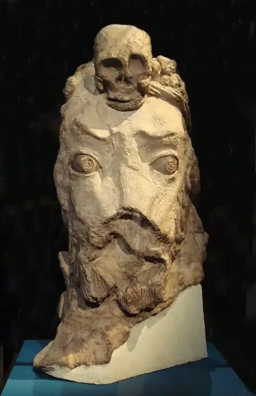
Terracotta head from the Kuva site in the Ferghana Valley.
ARCHAEOLOGICAL / MUSEUM EVIDENCE
06 / Core Central Asia

Ferghana

Cities, crossroads and debated temples

WHY IT MATTERED A productive valley linked to exchanges of horses, agriculture and culture.

READ THE FULL STORY HERE
DIGITAL HISTORY ATLAS · HISTORY, SOCIETY & EVIDENCE
TRADE FIRST / fertile valley and eastern approaches

A valley that connected mountain passes and eastern markets

The Ferghana Valley brought together irrigated agricultural centres, local rulers, mountain passes and access to corridors leading into the Tarim Basin and China. Horse breeding is frequently associated with the valley in older trade traditions, but that does not supply a seventh-century export tally.

Kuva’s religious sculptures demonstrate cultural encounters, not a shop inventory. Early medieval coins, town sites and Chinese accounts offer different kinds of evidence for Ferghana’s place in Eurasian connections.

Historical setting

Ferghana Valley

Political organisation

Rival local authorities and overlapping diplomatic claims are attested; a single unbroken colour on the map would conceal this complexity.

Silk Roads significance

Agricultural cities, craft traditions and connections to Tang and Türk political networks shaped the valley.

Evidence & limits

UNESCO III, Ch. 10, section on Ferghana, from p. 262. Religious identification at Kuva is disputed.

THE BUILT WORLD / RUINS, PLANS AND SURVIVALS

What did this place look like?

Akhsikent’s surviving mud-brick remains and finds give a physical setting; archaeological objects from Kuva reveal richly decorated interiors. Dates and interpretations of individual temples remain disputed.

OBJECTS · ARCHITECTURE · CONTEXT

Architecture, craftsmanship & evidence

These are distinct types of evidence. Reconstructed plans and later buildings are marked as such; no reconstruction is passed off as a surviving seventh-century photograph.

VISUAL EVIDENCE / 6 ORIGINAL FILES

Photographs and object images from the research archive. Select an image to examine it more closely without leaving this dossier.

HISTORICAL STUDY · Central Asia, 500–800 CE. Historical period: 500–800 CE.

A valley with several centers

Early medieval Ferghana was a fertile mountain-rimmed valley with farming, markets and horse breeding, but it should not be imagined as a politically uniform province. The UNESCO historical synthesis describes a number of local dominions and a ruling title, ikhshid, while scholarly summaries emphasize the complexity of internal power. Kasan, Akhsikent, Kuva/Quva, Osh and Uzgend belong on a connected historical gazetteer, not a list of interchangeable capitals. [CL-206, CL-209–210; UNESCO pp.275–276; Bosworth, “Farghana ii”]

The problem of 726 and 739

UNESCO records two rulers in 726, one linked to the Turks in the north and one to the Arabs in the south. For 739, UNESCO mentions the Türk ruler Arslan Tarkhan, while a separate historical article describes an Arab military and administrative effort in the same year. These statements may concern different relationships of authority. Neither gives a source-drawn line dividing the valley. The atlas should provide an evidence panel rather than a crisp two-color map. [CL-207–208; UNESCO p.275; Bosworth, “Farghana ii”]

Archaeology and cultural encounter

At Quva, excavators studied a temple and clay sculptures dating to the 7th or early 8th century. Their interpretation is debated. An older interpretation identified Buddhist imagery; a later interpretation links the sculptures to Sogdian gods, including Ahura Mazda represented with Indic features. The site therefore illustrates both cultural exchange and the difficulty of identifying religious images by appearance alone. Coins carrying Sogdian writing and other archaeological objects also reveal connections between Ferghana and neighboring Sogdian communities without erasing local traditions. [CL-211–212; UNESCO p.277; Marshak, “Farghana i”]

Conquest is not conversion

Reports of campaigns around 712–713 cannot be converted into a statement that the region immediately became uniformly administered or Muslim. Bosworth describes the extension of Arab control and conversion as prolonged processes. This must be visible in map captions and chronology. [CL-213; Bosworth, “Farghana ii”]

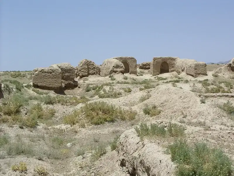
Archaeological panorama at Kala-i Kahkaha / Bunjikat.
ARCHAEOLOGICAL / MUSEUM EVIDENCE
07 / Core Central Asia

Ustrushana

The land between oases and mountains

WHY IT MATTERED A mountain-and-oasis corridor between Sogdiana and Ferghana.

READ THE FULL STORY HERE
DIGITAL HISTORY ATLAS · HISTORY, SOCIETY & EVIDENCE
TRADE FIRST / a regional passage, ruled locally

The hills between two commercial worlds

Ustrushana lay between the Samarkand region and Ferghana, making it an important part of the overland landscape through which people, crafts and ideas circulated. Local rulers maintained their own traditions even as surrounding political powers changed.

Bunjikat’s palace finds document elite workshops and patronage rather than precise trade statistics. A carved wooden figure or coin can reveal artistic skill and local authority without proving the journey of any particular merchant.

Historical setting

Central Asian highlands and oases

Political organisation

Local rulers known in later sources as afshins maintained political traditions under shifting outside influences.

Silk Roads significance

Mountain corridors, fortified seats and cultural links connected Samarkand, Chach and Ferghana.

Evidence & limits

UNESCO III, section on Ustrushana, starting p. 262. Later building phases require separate chronological labels.

THE BUILT WORLD / RUINS, PLANS AND SURVIVALS

What did this place look like?

Bunjikat/Kala-i Kahkaha preserves an excavated palatial complex with wall paintings and richly carved wood. The juxtaposition of ruins with surviving sculptures gives the most reliable picture of architecture without inventing completed façades.

OBJECTS · ARCHITECTURE · CONTEXT

Architecture, craftsmanship & evidence

These are distinct types of evidence. Reconstructed plans and later buildings are marked as such; no reconstruction is passed off as a surviving seventh-century photograph.

HISTORICAL STUDY — 500–800 CE.

Between Samarkand and Ferghana

Ustrushana lay between the Samarkand country and the Ferghana routes, stretching across mountain and lowland landscapes. Contemporary Chinese pilgrims and later geographers used different names and boundaries. Its connection with Sogdian speech and art is well documented in archaeological syntheses, but Ustrushana had its own regional identity. [CL-214; UNESCO vol.III pp.262, 264, 274; Bosworth, “Osrusana”]

Bunjikat and Kala-i Kahkaha

The royal seat Bunjikat is associated with the archaeological site of Kala-i Kahkaha, near modern Shahristan in Tajikistan. UNESCO places the site's marked urban expansion in the 7th–8th centuries, when palace architecture, carved wooden decoration and murals became prominent. Excavated rooms tell us about elites and courts; they do not describe every ordinary household. [CL-215, CL-217; UNESCO pp.262–268]

An independent ruling tradition

Members of the Afshin ruling tradition maintained local power through changing external political circumstances. Later accounts indicate that definitive submission to Abbasid authority is usually placed around 820; that date is outside this atlas's main 500–800 CE interval. A map labelled ‘Abbasid 750’ must not erase this local history. [CL-216, CL-219; UNESCO pp.263–264; Bosworth, “Osrusana”]

Images and interpretations

The paintings include a goddess sometimes identified as Nana, epic subjects, and images connected by scholars with dynastic ancestry. These are interpretive identifications, not ancient captions naming every figure. Original plates, plans and photos in UNESCO remain subject to separate reuse permissions. [CL-217–218; UNESCO pp.269–274]

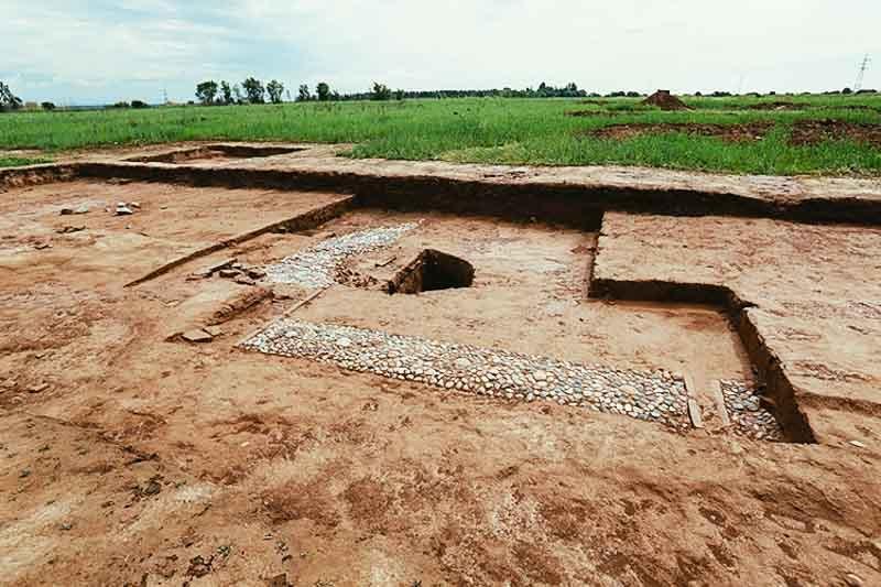
Modern remains of buildings, temples and streets in the town of Panjikent.
ARCHAEOLOGICAL / MUSEUM EVIDENCE
Connected Central Asia

Panjikent

Sogdian houses, temples and paintings

WHY IT MATTERED A town where houses, reception rooms and craft life illuminate Sogdian society.

READ THE FULL STORY HERE
REGIONAL CONNECTION · EVIDENCE & CONTEXT
TRADE FIRST / the lived-in anatomy of a Sogdian city

The merchants’ world, seen from inside a city

Panjikent is indispensable because excavation exposes not only elite monuments but also the rhythm of an urban community: houses, painted reception halls, workshops, streets and temples. The town was part of the Sogdian-speaking networks connecting the Zerafshan valley to the wider Silk Roads.

A large number of painted houses does not mean all inhabitants were wealthy caravan merchants. Their images show the values, stories and contacts of residents; written records and external evidence must do the work of identifying particular trade relationships.

ADDITIONAL MATERIAL EVIDENCE

Look closer: what survives?

These are dated or attributed objects and present-day archaeological views. None is presented as proof of a particular sale.

Turgar issue, two sidesA regional coin associated with Sogdian rulership, not a cash register.Attribution as supplied in image title; object record check pending.
Historical setting

Sogdian city east of Samarkand

Political organisation

A local ruling and aristocratic milieu is visible in excavated residences and surviving documents; regional overlordship is not the whole story.

Silk Roads significance

Excavated houses, decorated halls, temples, craft activity and archives make it central to the social history of Sogdiana.

Evidence & limits

UNESCO III, pp. 244–249; de la Vaissière, p. 106.

THE BUILT WORLD / RUINS, PLANS AND SURVIVALS

What did this place look like?

Excavated plans, an aerial view and modern architectural reconstructions can be compared side by side. The labelled room model is explicitly interpretive; its reception hall is not a surviving intact building.

OBJECTS · ARCHITECTURE · CONTEXT

Architecture, craftsmanship & evidence

These are distinct types of evidence. Reconstructed plans and later buildings are marked as such; no reconstruction is passed off as a surviving seventh-century photograph.

VISUAL EVIDENCE / 9 ORIGINAL FILES

Photographs and object images from the research archive. Select an image to examine it more closely without leaving this dossier.

Seeing the city more clearly

This version avoids the generic modern-view problem: the main image now focuses on excavated architecture in a more immersive way. Panjikent matters because it preserves houses, halls, temples, archives and paintings that let us talk about lived Sogdian urban history—not just a point on a map.

  • Domestic ceremonial halls with paintings
  • Temple remains and debated religious interpretation
  • Documents and social life tied to the Divashtich horizon

Status: Research study · Historical interpretations are supported by the cited evidence.

Then / Now: Panjikant / Panjikent (Sogdian Pancyknδ) / Ruins beside present-day Panjakent, western Tajikistan

The ruins of Panjikent preserve evidence of an early medieval Sogdian city, founded in the fifth century CE. Excavations of houses, fortified quarters and temples have made it one of the key sites for studying urban life and visual culture in Sogdiana. [CL-069, CL-071, CL-073]

The growth of a fortified town

The settlement expanded rapidly after its fifth-century foundation. By the end of that century its fortified urban area had reached an estimated 13.5 hectares, a figure given for the city without its citadel. This is a reported archaeological measurement, not yet suitable for a precise map boundary. [CL-070]

Homes, crafts and painted rooms

Excavation documents mud-brick and loess buildings as well as changing residential layouts. Private houses contained wall paintings by the sixth century; surviving images help historians investigate ritual, stories and social life, though individual scenes must be interpreted with care. [CL-073, CL-074]

Temples and questions of belief

Two temples built in the fifth century remained significant features of the urban landscape and were altered over time. Their existence is established archaeologically, but the evidence does not securely identify a single religious dedication for both buildings. [CL-071, CL-072]

The city’s later occupation

Marshak reports that the archaeological town remained occupied into the 770s. This should be checked against excavation reports before treating that decade as an exact end date for the entire settlement. [CL-075]

What remains uncertain

The identification of the major temples' particular cults remains uncertain; some late political chronologies require further checking.

Sources and confidence

  • CL-069 — High: The early medieval Sogdian city of Panjikent was founded in the fifth century CE. B. I. Marshak and N. N. Negmatov (chapter 10); volume ed. B. A. Litvinsky et al. (1996), p. 239, Étienne de la Vaissière; trans. James Ward (2005), p. 106 (PDF p. 122), Boris I. Marshak (2002), section: archaeology/site description. Note: Writers may draw on overlapping excavation evidence; this is not three independent excavations.
  • CL-070 — Medium: Panjikent’s fortified urban area expanded to approximately 13.5 hectares by the late fifth century, excluding the citadel in UNESCO's measurement. B. I. Marshak and N. N. Negmatov (chapter 10); volume ed. B. A. Litvinsky et al. (1996), p. 244, Étienne de la Vaissière; trans. James Ward (2005), p. 106 (PDF p. 122), Boris I. Marshak (2002), section: city description. Note: This is a historical estimate, not a polygon to be drawn on the map.
  • CL-071 — High: Two temples were constructed at Panjikent in the fifth century and were rebuilt over time. B. I. Marshak and N. N. Negmatov (chapter 10); volume ed. B. A. Litvinsky et al. (1996), p. 247, Boris I. Marshak (2002), section: description of the site. Note: Presence of temples is supported; precise deity/denomination is not.
  • CL-072 — Disputed: The specific religious dedication of Panjikent's two major temples cannot be securely established from the surviving images. B. I. Marshak and N. N. Negmatov (chapter 10); volume ed. B. A. Litvinsky et al. (1996), p. 247, Boris I. Marshak (2002), section: temples and cult. Note: Do not assign the whole complex to a single religion as an undisputed fact.
  • CL-073 — High: Mural painting decorated private houses at Panjikent by the sixth century CE, and the murals included religious and narrative scenes. B. I. Marshak and N. N. Negmatov (chapter 10); volume ed. B. A. Litvinsky et al. (1996), pp. 246–248, Boris I. Marshak (2002), section: description of houses and murals. Note: Specific subjects of individual paintings require object-level cataloguing.
  • CL-074 — High: Early medieval Panjikent houses used loess and mud brick, with architectural changes and denser building during the sixth to eighth centuries. B. I. Marshak and N. N. Negmatov (chapter 10); volume ed. B. A. Litvinsky et al. (1996), pp. 245–246. Note: Architectural description should not be treated as a universal model for every house.
  • CL-075 — Medium: The archaeological city of Panjikant remained inhabited into the 770s, according to Marshak's summary of the excavations. Boris I. Marshak (2002), section: description of site; occupation chronology. Note: A date reported by this author; independent stratigraphic check is still outstanding.

Image policy: No images from books are embedded. Use only permission-cleared museum images with attribution.

Map policy: No historically reconstructed GeoJSON is supplied at this stage.

Modern excavation at Ak-Beshim, identified with the historic city of Suyab in the Chu Valley.
AK-BESHIM / MODERN EXCAVATION
Connected Central Asia

Suyab

Connected Türk–Sogdian urban world

WHY IT MATTERED A meeting place for Sogdian communities and Turkic political networks.

READ THE FULL STORY HERE
REGIONAL CONNECTION · EVIDENCE & CONTEXT
THE EXCAVATED CITY / MODERN PHOTOGRAPHY

Three views of the Ak-Beshim archaeological context. These images document modern excavations and surviving remains, not a reconstruction of the city in the seventh century.
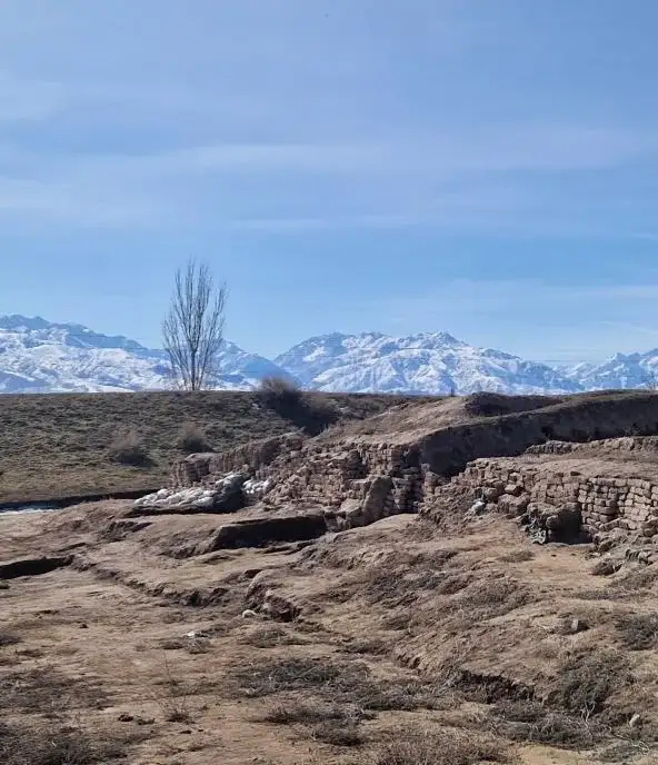
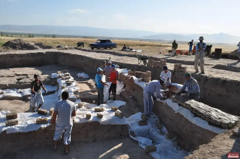
Excavated foundations and stone features at Ak-Beshim
Excavated foundationsArchaeological remains at Ak-Beshim, associated with ancient Suyab.
Present-day mudbrick ruins at Ak-Beshim with mountains in the background
Surviving cityscapeRemains of the ancient settlement, in their present-day landscape.
Archaeologists working on an excavated structure at Ak-Beshim
Field excavationArchaeological work at the site. Image source: Open.kg; reuse permission to be verified.
TRADE FIRST / a Chu Valley trading and diplomatic nexus

A crossroads became a shared world

Suyab, generally identified with Ak-Beshim in the Chu Valley, was a hub of contact between Sogdian settlers, Turkic rulers and people traveling to and from eastern oases. Written traveller testimony describes western merchants in the region during the seventh century.

Rather than inventing an ancient bazaar or a neat border line, we show the archaeological record of multiple religious sites and the surviving written evidence. An exact total trade volume or merchant population is unavailable.

Historical setting

Connected steppe–oasis corridor

Political organisation

Türk, Sogdian and Chinese political and cultural influences intersected at the Chu valley urban centres.

Silk Roads significance

It is included as connected context, not as a replacement for the Central Asian core of this atlas.

Evidence & limits

de la Vaissière, Chs. 4–7; UNESCO III, Ch. 14. Chronology and political status are debated.

THE BUILT WORLD / RUINS, PLANS AND SURVIVALS

What did this place look like?

Excavations at Ak-Beshim reveal religious and urban structures of different phases, including Buddhist and other contexts. The card uses a modern archaeological view of the site as contextual evidence rather than an unrelated monument or a speculative reconstruction.

Historical study for The Silk Roads — Through Central Asia · 500–800 CE.

City on the Chu River

The ancient city Suyab is generally identified with Ak-Beshim, an archaeological site in the Chu Valley in present-day Kyrgyzstan. Gregory Semenov dates its probable foundation by Sogdian communities to the sixth century. The qualifier probable matters: it is not a contemporary foundation inscription fixing a year. [CL-225–226; Semenov, “Suyāb,” opening section; UNESCO WHC 1442-008]

Languages, courts, and religious sites

Suyab occupied a zone of contact between mobile Turkic polities and settled communities linked to Sogdian culture and China. Excavations have revealed Buddhist shrines, a Zoroastrian cemetery and Christian remains. These belong to different excavated contexts and are not proof that all confessions were equally established in the same year. An inscribed Chinese stone, associated with an official whose tenure falls approximately between 682 and 709, is particularly important to the identification of the ancient city. [CL-227–228; Semenov, “Suyāb”]

Merchants and travellers

A text attributed to the pilgrim Xuanzang, discussed by Étienne de la Vaissière, records a meeting place of western merchants in the early seventh century. This is the voice of a visitor who had an outside view of the society, not a census. The surrounding Chu Valley towns were agricultural and political settlements as well as marketplaces. [CL-229–231; de la Vaissière, Sogdian Traders pp.114–116]

The struggle over Suyab

Suyab stood within changing spheres of Western Türk, Türgesh and Tang influence. UNESCO records its place among the frontier garrisons of the Tang protectorate and notes its replacement in the list by Karashahr after 719; the same volume mentions a Tang capture of Suyab in 748. These are distinct episodes, not evidence that the entire valley had one continuous, stable form of rule. [CL-237, CL-244; UNESCO vol. III pp.290, 342]

On the interactive map

The map can show one clickable point using the modern UNESCO site locator (Component 1442-008), an evidence panel, and dated event cards. It must not show an invented town wall, religious district polygon, or exclusive Tang political border without an independent spatial reconstruction. [CL-245; UNESCO WHC map]

Sources: Semenov, “Suyāb” (2002); UNESCO WHC corridor 1442; de la Vaissière (2005) pp.114–116; UNESCO (1996) pp.290, 341–342. All text is a paraphrase; no museum images copied.
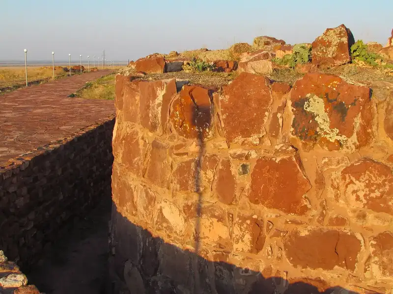
Architectural remains of the Akyrtas monumental complex in the wider Taraz region.
ARCHAEOLOGICAL / MUSEUM EVIDENCE
Connected Central Asia

Taraz

Talas valley archaeological record

WHY IT MATTERED A northern meeting point described by travellers and connected to the Talas corridor.

READ THE FULL STORY HERE
REGIONAL CONNECTION · EVIDENCE & CONTEXT
TRADE FIRST / northern corridor and traveller testimony

Where travelers crossed languages and markets

The Talas/Taraz region stood in the northern belt linking Central Asian oasis communities and Turkic territories. The pilgrim Xuanzang’s seventh-century account, discussed in scholarship, describes merchants from different western lands. This is evidence of a cosmopolitan meeting point, not a numerical count of trades.

The 751 battle near the Talas River belongs to political history and should not be used as a simplistic proof that all east–west commerce stopped. Regional links changed but were not a single route controlled by one party.

ARCHITECTURE IN CONTEXT

Look closer: the Talas region in stone

Akyrtas is a monumental architectural site near Taraz, not a surviving building of the ancient town itself. Its dating and purpose have been debated; the photograph helps compare the surrounding architectural landscape without inventing an early medieval marketplace.

Akyrtas near TarazMonumental stone complex in the wider Talas region, not Taraz's excavated commercial district.Dating and function debated; Ancient Taraz Museum-Reserve ↗
Historical setting

Connected Talas valley

Political organisation

Local urban life under changing regional states cannot be inferred from the later monuments alone.

Silk Roads significance

Archaeology and routes through the Talas valley help explain Sogdian and Türk connectivity.

Evidence & limits

UNESCO III, political and geographic chapters; archaeological studies from the research catalogue. The battle of 751 has no arbitrarily plotted point.

THE BUILT WORLD / RUINS, PLANS AND SURVIVALS

What did this place look like?

Taraz’s own archaeology contains several building phases. Akyrtas, a monumental complex in the broader region, may be shown as a contextual comparison, never as the ancient bazaar of Taraz; its date and function remain debated.

OBJECTS · ARCHITECTURE · CONTEXT

Architecture, craftsmanship & evidence

These are distinct types of evidence. Reconstructed plans and later buildings are marked as such; no reconstruction is passed off as a surviving seventh-century photograph.

Historical focus: 500–800 CE; later archaeological comparanda are identified separately.

A city in a connected valley

The historic town of Talas/Taraz was known to travellers moving across the northern Central Asian routes. The pilgrim Xuanzang, as translated and discussed by de la Vaissière, describes merchants from different western lands there around 630. His itinerary illustrates connectivity, not an exact route line: we cannot draw each day's path from this statement. [CL-233; de la Vaissière, Sogdian Traders p.116]

What was excavated?

An archaeological report records early material dating to the seventh and eighth centuries in a Taraz excavation, together with many later occupation layers. Reports of a bathhouse and fire-shrine from excavations in the present central market area likewise concern complex medieval stratigraphy. Neither report licenses us to display every excavated building as if it stood in the year 600. [CL-234–235; Baipakov, “Research in Taraz and Talas Valley”; Dawkes and Jorayev (2015) abstract]

Jamukat and the Sogdian story

The site Kostobe is commonly connected with Jamukat. In the account preserved by Narshakhi and discussed by de la Vaissière, displaced Bukhara nobles are said to have founded a settlement near Taraz. It is a striking story of people carrying agricultural and social practices northwards — but a tenth-century narrative about the sixth century requires a cautious presentation alongside archaeology. [CL-236; de la Vaissière pp.114; Ancient Taraz Museum-Reserve, “Kostobe”]

751: The Battle near the Talas River

A major confrontation occurred near the Talas River in 751 between Tang troops and forces led by Arab commanders with Turkic allies. Its precise battlefield location is not fixed by our sources. Nor is its consequence agreed upon: UNESCO connects the battle to Tang retreat, whereas de la Vaissière emphasizes Tang activity afterward and the later An Lushan rebellion. The atlas should display both readings, not an absolute military turning point with a fictional battlefield pin. [CL-238–240; UNESCO vol. III pp.291, 342, 344; de la Vaissière p.266]

Evidence-based interactions

Create tabs for traveller testimony, excavation, and battle interpretations; a slider with 751 and 755 event markers; and a nearby official modern archaeological point for Kostobe. No line follows an invented caravan path and no photograph is licensed by this research package.

Sources: de la Vaissière (2005) pp.114–116, 266; UNESCO (1996) pp.291, 342, 344; Baipakov report; Dawkes/Jorayev (2015, abstract only); Kostobe museum record.

Related region: Panjikent ↗   Suyab ↗   Taraz ↗

WHY SOGDIANA HAS ITS OWN CHAPTER

Not one city.
A whole trading society.

Samarkand, Bukhara and Panjikent were different cities. Sogdiana was a historical region and a network of Sogdian-speaking communities embracing multiple oases, towns and merchants abroad—not one state with borders matching present-day Uzbekistan. That is why our site explores cities above and then gives Sogdian art, language, beliefs and trade their own connected stories below.

01 / HOME

Where did merchants begin?

Farms, workshops, courts and homes were the economic infrastructure behind caravans.

OPEN EVIDENCE +

Samarkand, Bukhara and neighbouring oasis cities drew on irrigated agriculture, specialised workshops and dense settlement networks. The Sogdian homeland mattered because it produced goods, skills and merchant relationships—not simply because roads crossed it.

Kafir Kala gate remainsKafir Kala is a distinct fortified site in the Samarkand oasis. It helps evoke settlements that anchored the landscape, not a universal caravanserai plan.A distinct site in the Samarkand region; do not mistake it for Afrasiab itself.
Smithsonian · Route geography ↗
02 / ABROAD

Why did families settle in China?

The trading world was built by diaspora communities, not one endless moving caravan.

OPEN EVIDENCE +

Documents and tombs from settlements such as Turfan and Chang’an illuminate the lives of Central Asian families abroad. Some worked in trade; others served as artisans, farmers, entertainers, religious officials or soldiers. Their lives connected societies far beyond the duration of a single commercial trip.

Tang camel with musiciansA Tang-period musicians-on-camel figurine: an artistic representation of mobile people, not a portrait of identifiable Sogdians in transit.Representation from Tang China, not direct evidence of a Sogdian merchant’s profit.
Smithsonian · Sogdians abroad ↗
03 / CONTRACTS & POWER

Who gained—and who paid?

Commercial exchange was shaped by rulers, military conflict, obligations and exploitation.

OPEN EVIDENCE +

Trade was not an uninterrupted story of prosperity. Political negotiations could open or obstruct markets. Surviving contracts and tax documents also describe human exploitation, including enslavement. The eighth century brought conquest and conflict that changed the trading environment.

Sogdian-language contract, 639 CEA document dated 639 CE is identified as a contract involving enslaved people. We include it as evidence of the human costs of commerce, not a game item.An important reminder that trade history includes coercion and exploitation; original translation must be verified before quoting.
Iranica · Trade, contracts and disruption ↗

Research collection Discover all ten places and ten stories in one searchable index.

Open Explore ↗
The guiding question
What changes when Central Asia becomes the subject of history—not merely a passage between other worlds?
06 / THE TRADERS AND THEIR CULTURES

Beyond goods: the people who moved them

Regional art, languages, religion, writing and political changes all helped shape commercial networks. Open these thematic dossiers for a deeper historical explanation.

01 / Core Central Asia

Art of Sogdiana

Murals, woodcarving and encounters

Art that travelled with people

READ THE FULL STORY HERE
DIGITAL HISTORY ATLAS · HISTORY, SOCIETY & EVIDENCE
THE TRADING WORLD / THEMATIC PERSPECTIVE

Art that travelled with people

Motifs and techniques moved through trade, pilgrimage and political gifts. The famous wall paintings of Panjikent and Afrasiab are windows into patrons and beliefs, but they are not inventories of exports.

OBJECTS · ARCHITECTURE · CONTEXT

Visual evidence in context

Photographs of surviving objects and modern scientific reconstruction drawings. Attribution, chronology and image rights are recorded as provisional.

VISUAL EVIDENCE / 6 ORIGINAL FILES

Photographs and object images from the research archive. Select an image to examine it more closely without leaving this dossier.

Walls as storytelling surfaces

For the fifth to eighth centuries CE, architecture and painted decoration are crucial evidence for Sogdian culture. Researchers describe religious imagery, mythic and epic narratives, banquets, hunting scenes and ornamental panels, often in rooms intended for ceremony or reception. Much of our detailed knowledge comes from the excavation of Panjikent, with important monuments also at Afrasiab (Samarkand) and the palace of Varakhsha. [CL-105; SRC-001 pp. 246–248; SRC-014, Mural painting]

The household as a social and artistic setting

According to the UNESCO synthesis, by the early eighth century approximately one in three houses in Panjikent contained murals. This observation is specific to that excavated city and should not be converted into a statistic for Sogdiana or Varakhsha as a whole. Some domestic ceremonial halls combined religious figures with narrative or festive scenes. Their subject matter suggests the social uses of display and reception, but does not give us a transcript of daily life. [CL-105; CL-106; SRC-001 pp. 246–247]

Images moving between regions

Sogdian visual culture shows interactions with Iran, India, steppe societies and China. The many distinct influences are not interchangeable; each particular artwork has to be studied in its own archaeological and stylistic context. The elephant imagery at Varakhsha, for example, is frequently compared to Indian iconography without settling the pictured figure's divine identity. [CL-098; CL-107; SRC-001 p. 248; SRC-012]

Wealth, craftsmen and the material world

Silver vessels were an important medium of Sogdian elite art. The UNESCO volume observes that ceramic tableware of the late seventh and early eighth centuries began to echo the forms of prestigious metal vessels. This is a regional observation: it does not establish that a named Varakhsha workshop made any specific surviving object. [CL-108; SRC-001 p. 243; SRC-014, Decorated silver vessels]

Religion without forced certainty

Religious practice appears in painted images, excavated sanctuaries and surviving texts. Nevertheless, some cultic attributions are hard to verify. UNESCO cautions that the patron religion of two Panjikent temples cannot be determined with certainty because their main worship images have not survived. Similarly, the identity and symbolic purpose of the Varakhsha Red Hall's elephant-riding figure remain debated. Our website will record competing hypotheses, rather than attaching definitive labels to uncertain images. [CL-099; CL-110; SRC-001 p. 247; SRC-014]

02 / Core Central Asia

Beliefs of Sogdiana

Sacred images and historical uncertainty

Merchants carried ways of thinking, too

READ THE FULL STORY HERE
DIGITAL HISTORY ATLAS · HISTORY, SOCIETY & EVIDENCE
THE TRADING WORLD / THEMATIC PERSPECTIVE

Merchants carried ways of thinking, too

Religion travelled through the same zones as commerce, but a figurine of a deity does not tell us what a caravan sold. The region held a diversity of traditions; surviving monuments belong to different communities and periods.

OBJECTS · ARCHITECTURE · CONTEXT

Visual evidence in context

Photographs of surviving objects and modern scientific reconstruction drawings. Attribution, chronology and image rights are recorded as provisional.

VISUAL EVIDENCE / 7 ORIGINAL FILES

Photographs and object images from the research archive. Select an image to examine it more closely without leaving this dossier.

HISTORICAL STUDY · Interpretations and visual attributions are documented below. Geography: Sogdiana, with most detailed archaeological examples from Panjikent. Historical focus: fifth–eighth centuries CE.

More than a single religious label

Sogdiana's religious landscape cannot be reduced to a modern, uniform confessional map. A locally distinctive form of Mazdaism (Zoroastrian traditions) was prominent, but other religious practices, deities, and imported ideas were present. Our evidence ranges from excavated art and funerary remains to Buddhist, Manichaean, and Christian texts, many of the latter preserved outside Sogdiana. A surviving text from a migrant community is not proof that its religion dominated Samarkand or Panjikent. [CL-111, CL-112; UNESCO 1996 pp.249,255; Lerner, Believers, Proselytizers, & Translators]

The goddess Nana and the challenge of interpretation

The goddess Nana was particularly important in Sogdian imagery. Some representations show a multi-armed goddess riding or seated on a lion. Her history connects Sogdian belief with older traditions of Mesopotamia and the broader Iranian and Kushan worlds. Not every unlabeled female figure can be identified as Nana: specific attributions require evidence and remain interpretive. [CL-113; UNESCO 1996 p.253; Lerner, Religion among the Sogdians, section on Nana]

Temples and household worship

Two major temples at Panjikent were founded in the fifth century and rebuilt across successive phases. UNESCO cautions that their precise religious dedication is difficult to determine because the original principal objects of worship have not survived. At the same time, surviving murals from domestic ceremonial halls show divine patrons and worshippers, often near a fire altar. It is important to distinguish recognizable ritual motifs from a definitive classification of an entire temple or community. [CL-114, CL-115; UNESCO 1996 p.247; Mode, Sogdian Art, Mural painting]

The dead and the world beyond

Some Sogdian mortuary practices involved the exposure or defleshing of bodies and preservation of bones in clay ossuaries. At Panjikent, small structures (naos) outside the settlement contained such vessels. The famous mural conventionally called Mourning Scene, excavated in Temple II, depicts elaborate images of grief and the divine world; its significance is discussed by researchers. A painting is not a literal documentary photograph of a particular funeral, and not all inhabitants necessarily followed identical practices. [CL-116, CL-117; UNESCO 1996 p.255; Brey, Panjikent Town-Planning; Smithsonian The Sogdians at Home, Fig.49]

Changing centuries

The expansion of Arab-Muslim political control in the eighth century transformed Sogdian religious and civic life, but not everywhere or all at once. Following conflict in 722, Panjikent experienced destruction, reconstruction, and changing patterns of worship. An atlas timeline should connect such events to the specific city and evidence, not abruptly change a whole region's religion in one year. [CL-130; Brey, Panjikent Town-Planning; Marshak, Panjikant]

Primary research locators

  1. B. I. Marshak and N. N. Negmatov, “Sogdiana,” in B. A. Litvinsky (ed.), History of Civilizations of Central Asia, vol. III (UNESCO, 1996), pp. 247, 249, 252–255. https://unesdoc.unesco.org/ark:/48223/pf0000104612_eng
  2. Judith A. Lerner, “Believers, Proselytizers, & Translators: Religion among the Sogdians,” Smithsonian National Museum of Asian Art, online essay, opening and Nana sections. https://sogdians.si.edu/believers-proselytizers-translators/
  3. Markus Mode, “Sogdiana iv. Sogdian Art,” Encyclopaedia Iranica, 2009 (updated 2018), Mural painting section. https://www.iranicaonline.org/articles/sogdiana-vi-sogdian-art/
  4. Alexander Brey, “The City of Panjikent and Sogdian Town-Planning,” Smithsonian, cemetery and later history sections. https://sogdians.si.edu/sidebars/the-city-of-panjikent-and-sogdian-town-planning/
  5. Boris I. Marshak, “Panjikant,” Encyclopaedia Iranica, 2002, Religion; Later history. https://www.iranicaonline.org/articles/panjikant/

Editorial notes: Articles are overlapping scholarly syntheses, not automatically independent original excavations. No protected illustrations are included. Keep all religious typologies contextual and provisional.

03 / Core Central Asia

Daily life

Houses, workshops, music and clothing

The economy inside the home

READ THE FULL STORY HERE
DIGITAL HISTORY ATLAS · HISTORY, SOCIETY & EVIDENCE
THE TRADING WORLD / THEMATIC PERSPECTIVE

The economy inside the home

Food, storage, domestic production and reception spaces mattered as much as the caravan. Archaeology provides rooms and objects; it does not turn every resident into an international merchant.

OBJECTS · ARCHITECTURE · CONTEXT

Visual evidence in context

Photographs of surviving objects and modern scientific reconstruction drawings. Attribution, chronology and image rights are recorded as provisional.

VISUAL EVIDENCE / 2 ORIGINAL FILES

Photographs and object images from the research archive. Select an image to examine it more closely without leaving this dossier.

HISTORICAL STUDY · Interpretations and visual attributions are documented below. This is an evidence-led tour, not a fictional reconstruction of a particular citizen's day. Most details concern excavated Panjikent between the fifth and eighth centuries CE.

Streets and building materials

Panjikent grew from a modest settlement of mud-brick and packed-earth buildings into a more densely built town. A network of streets connected houses, temples, places of administration, workshops and shops. By the late seventh and early eighth centuries, larger houses sometimes rose to two or even three storeys. This tells us about changing urban space, not how every family lived. [CL-120, CL-121; UNESCO 1996 pp.245–246; Brey, Panjikent Town-Planning]

Inside a reception hall

Some prosperous homes had a formal reception room with low plastered-clay benches (sufa) around the walls. Rich paintings might feature a patron deity opposite the entrance, alongside narrative bands showing feasts, hunts, fables or epics. UNESCO describes mural decoration in about one third of Panjikent houses by the early eighth century, an estimate for that excavated city and period—not an empire-wide statistic. The paintings reflect ideals, rituals and storytelling as much as material reality. [CL-115, CL-118, CL-119, CL-123; UNESCO 1996 pp.246–247; Smithsonian, The Sogdians at Home]

Shops and workshops

Merchants and craftspeople were part of Panjikent's urban fabric. Excavation summaries describe small workshops and retail premises along streets; some were leased from wealthy property owners. Our atlas can explain this using sourced artefact cards, but cannot assign an invented family name or merchant to an unrecorded shop. [CL-122; UNESCO 1996 p.246; Brey, Panjikent Town-Planning]

Dressing the part

Wall paintings preserve numerous images of belted caftans, elaborate textiles, and sometimes ceremonial robes and tunics. Women in certain religious scenes appear with caftans draped over their shoulders. Fashions varied over time, place and setting; divine and epic imagery might be deliberately fantastic. Very little securely excavated clothing survives, making a child's cotton caftan from Sanjar-Shah especially important. It is not evidence for everyone's daily dress. [CL-124–126; Naymark, Clothing vi; Hensellek, Sogdian Fashion]

What the pictures tell us about music

Sogdian visual evidence includes lutes, angular harps, flutes and hourglass drums, including in Panjikent murals and Sogdian funerary monuments in China. This gives evidence of types of instruments and their depiction, not recoverable sheet music or exact sounds. We will not present an invented soundtrack as authentic music from seventh-century Sogdiana. [CL-127; Bo Lawergren, Music History i, section on Sogdian instruments]

What merchants carried — and what we cannot infer

Étienne de la Vaissière discusses the fragmentary customs register of Turfan, which documents goods in Sogdian-linked long-distance trade: precious metals, metals, scented products, medicinal materials and silk-related goods. His study also explains the role of silk as a kind of money within some Chinese economic settings. That is valuable for a trade section, not a typical Panjikent household shopping list. [CL-128, CL-129; de la Vaissière, Sogdian Traders (2005), pp.174–176]

Interactive sections ready for later development

  • Explore a house: text-and-source evidence hotspots, not an imaginary excavated blueprint.
  • Behind a market stall: Turfan customs entries with citations and context.
  • Clothing archive: link individual identified objects, dating and rights.
  • Music and movement: view real instrument depictions, no invented historical audio.
  • Sources and uncertainty: open any claim's evidence and see its limitations.

Research sources and exact locations

  • UNESCO, History of Civilizations of Central Asia, vol. III (1996), pp.243, 245–249. https://unesdoc.unesco.org/ark:/48223/pf0000104612_eng
  • Alexander Brey, “The City of Panjikent and Sogdian Town-Planning,” Smithsonian, housing, workshops and settlement. https://sogdians.si.edu/sidebars/the-city-of-panjikent-and-sogdian-town-planning/
  • Julie Bellemare and Judith A. Lerner, “The Sogdians at Home,” Smithsonian, reception hall, Inside Out. https://sogdians.si.edu/the-sogdians-at-home/
  • Aleksandr Naymark, “Clothing vi. Of the Sogdians,” Encyclopaedia Iranica (1992), male clothing and material basis. https://www.iranicaonline.org/articles/clothing-vi/
  • Betty Hensellek, “Sogdian Fashion,” Smithsonian, Introduction; The Kaftan. https://sogdians.si.edu/sidebars/sogdian-fashion/
  • Bo Lawergren, “Music History i. Pre-Islamic Iran,” Encyclopaedia Iranica (2009), Sogdian instruments in China. https://www.iranicaonline.org/articles/music-history/music-history-i-pre-islamic-iran/
  • Étienne de la Vaissière, Sogdian Traders: A History (Brill, 2005), pp.174–176. English edition PDF already archived in the project.

Status: research-led interpretation; permissions for reproducing primary objects and sound recordings are not assumed.

04 / Core Central Asia

The Sogdian script

A language that travelled far

A network could write across distance

READ THE FULL STORY HERE
DIGITAL HISTORY ATLAS · HISTORY, SOCIETY & EVIDENCE
THE TRADING WORLD / THEMATIC PERSPECTIVE

A network could write across distance

Sogdian writing circulated among communities across Central Asia and China. Manuscripts and inscriptions reveal linguistic reach; not all preserved manuscripts come from 500–800 CE.

OBJECTS · ARCHITECTURE · CONTEXT

Visual evidence in context

Photographs of surviving objects and modern scientific reconstruction drawings. Attribution, chronology and image rights are recorded as provisional.

HISTORICAL STUDY · Evidence and interpretation. Core focus 500–800 CE; early documents and later descendants are clearly identified as background and legacy. The sources are named in each section and linked below.

A language spoken far beyond Sogdiana

Sogdian was an Eastern Middle Iranian language associated with the region of Samarkand, Bukhara and nearby settlements. In trading communities farther east, it also served as a medium of communication across linguistic boundaries. The archive that survives is geographically uneven: many manuscripts were discovered in Turfan or Dunhuang, rather than in the heartland of Sogdiana. Their place of discovery must not be mistaken for the place where their contents originated. [CL-131, CL-135; Yoshida 2016, introduction and Materials; Sims-Williams, Sogdian Language and Its Scripts]

Three scripts, not one uniform handwriting

The Sogdian language could be written in the Sogdian script descended from Aramaic, as well as in Manichaean and Syriac scripts associated with different religious literatures. The national Sogdian script was employed in secular correspondence, documentary work and religious writing. Manuscript letters could be cursive, and formal book hands followed different conventions. A script is not the same thing as a language: some later writing systems took forms from Sogdian while recording other languages. [CL-132, CL-133; UNESCO 1996 p.255; Yoshida 2016, introductory section; Sims-Williams]

The Bugut inscription and the Türk world

At the end of the sixth century, the earliest Türk political setting included an inscription at Bugut written in Sogdian language and script. It illustrates the use of Iranian-speaking scribal skills in a Turkic imperial context. The exact date of the inscription is discussed differently in scholarship: our atlas records a broad late-sixth-century range instead of placing an unsupported exact-year pin. [CL-145; de la Vaissière 2005 pp.202–203; Doerfer 1991, passage on Bugut]

From Sogdian to Old Uighur — and much later scripts

Sogdian writing contributed to the development of the Old Uighur script. Mongolian and Manchu scripts were ultimately linked to this writing lineage in later centuries. The latter links are a story of later reception, not evidence that Mongolian or Manchu scribes worked in Samarkand in 650 CE. [CL-146; de la Vaissière 2005 p.202; Sims-Williams, script inheritance]

Religious translation and written culture

The manuscripts recovered from western China include Buddhist, Manichaean and Christian Sogdian writings, often translations from Chinese or other Iranian and Syriac-language texts. UNESCO also describes literary narratives, including a fragment of the Rustam tradition. Those survivals demonstrate circulation of written ideas, but do not license us to assign a date, author, or original language to every anonymous fragment. [CL-147–148; UNESCO 1996 pp.255–259; Yoshida 2016, Materials and publications]

The language after the atlas period

The living Yaghnobi language is regarded as a descendant of a Sogdian dialect. This linguistic continuity is a modern epilogue, not a declaration that all cultural or political identities remained unchanged. [CL-134; Yoshida 2016, introduction]

References

  1. B. I. Marshak and N. N. Negmatov, “Sogdiana,” History of Civilizations of Central Asia, vol. III (UNESCO, 1996), pp.255–259: https://unesdoc.unesco.org/ark:/48223/pf0000104612_eng
  2. Étienne de la Vaissière, Sogdian Traders: A History (Brill, 2005), pp.202–203 (printed; PDF pp.226–227): bibliographic record https://catalogue.bnf.fr/ark:/12148/cb40009463n
  3. Nicholas Sims-Williams, “Sogdian Language and Its Scripts,” Smithsonian The Sogdians, language overview; script development; Bugut and Uighur sections: https://sogdians.si.edu/sidebars/sogdian-language/
  4. Yutaka Yoshida, “Sogdian Language i. Description,” Encyclopaedia Iranica (2016), introduction; Materials and publications: https://www.iranicaonline.org/articles/sogdian-language-01/
  5. Gerhard Doerfer, “Chinese Turkestan viii. Turkish-Iranian Language Contacts,” Encyclopaedia Iranica (1991), Bugut inscription passage: https://www.iranicaonline.org/articles/chinese-turkestan-viii/

Editorial limits: no fabricated glyph facsimiles, no images included from copyright holders, no exact map boundaries for a language, and no exact date assigned to the contested Bugut inscription.

05 / Core Central Asia

Letters & archives

Documents from Dunhuang to Mount Mugh

What paper can tell us—and what it cannot

READ THE FULL STORY HERE
DIGITAL HISTORY ATLAS · HISTORY, SOCIETY & EVIDENCE
THE TRADING WORLD / THEMATIC PERSPECTIVE

What paper can tell us—and what it cannot

Letters, contracts, archives and customs records provide firmer traces of transactions than beautiful objects alone. Read dated examples carefully: the famous Sogdian Ancient Letters are much earlier than our core period.

OBJECTS · ARCHITECTURE · CONTEXT

Visual evidence in context

Photographs of surviving objects and modern scientific reconstruction drawings. Attribution, chronology and image rights are recorded as provisional.

HISTORICAL STUDY · Evidence and interpretation. A source-led exhibit, not fictional correspondence. Source periods sometimes fall outside the website's main 500–800 CE interval.

Before 500: the Ancient Letters

The so-called Ancient Letters were discovered near Dunhuang, on China's northwestern frontier. They were written during the early fourth century and are known for their references to trade, communities and family concerns. Some were written on behalf of women. These voices matter, but a letter attributed to a woman is not proof that the surviving characters are in her own handwriting. [CL-136–137; Smithsonian, Ancient Letters; de la Vaissière 2005 pp.43–56]

Object to explore: Sogdian Ancient Letter 2, British Library Or.8212/95. The International Dunhuang Programme catalogue dates this paper manuscript to 313–314 CE, gives its dimensions as 42 × 24.3 cm and records pieces of brown silk wrapping with traces of an outer hemp covering. The Smithsonian gives a nearby but not identical date (312 or 313). We preserve this minor disagreement as a scholarly note. The object photograph is not bundled: the British Library catalogue includes a rights statement. [CL-138–139; IDP catalogue, Overview, Description and Rights]

709–710: a marriage contract with named people

A legal agreement from the Mount Mugh archive names Ot-tegin and Chat and is dated by a regnal year to approximately 709–710 CE. In this particular contract, Chat is granted the right to initiate a divorce without losing her dowry. The document is unusual historical evidence, not a basis for claiming that all Sogdian women had identical rights. The place where the contract was concluded is an inference, probably Samarkand, not a documented certainty. [CL-140–141; Yakubovich 2005/2017, Sogdian Marriage Contract, commentary and Nov.3]

722: the archive of Mount Mugh

The castle of Mount Mugh became the refuge of documents associated with Devashtich, ruler of Panjikent, during political upheaval in 722 CE. Archaeologists recovered records on paper, leather and wooden sticks, as well as texts in several languages. The collections include letters, legal documents and economic accounts. The quantity of ‘Sogdian documents’ differs across descriptions because catalogues count fragments or language groups differently. [CL-142, CL-144; UNESCO 1996 p.259; Pavel Lurje, The Castle on Mount Mugh and Its Documents]

A special warning belongs on the site's map. Devashtich used the title ‘king of Sogd, ruler of Samarkand,’ but it is not thereby demonstrated that he actually governed Samarkand. A ruler's title must not be turned directly into an administrative border. [CL-143; Lurje, same essay]

How the interaction will work

A reader selects a documented item from our catalogue. The panel shows the original inventory number, proposed date, find site, holding institution, writing material, and why this object matters. The evidence drawer links to a genuine scholarly object record. A future translated-text panel will be added only after checking a critical translation and rights. The layout will never display made-up ‘historical quotations’ or generated scans as real manuscripts.

References

  • British Library / International Dunhuang Programme, Or.8212/95, Sogdian Ancient Letter 2, object catalogue Overview; Description; Rights: https://idp.bl.uk/collection/A141F9841B0B4BE1BDDA4FE6E2265948/
  • Smithsonian National Museum of Asian Art, Ancient Letters, object explanation: https://sogdians.si.edu/ancient-letters/
  • Étienne de la Vaissière, Sogdian Traders (Brill, 2005), pp.43–56 (original scanned volume in the project).
  • Pavel Lurje, The Castle on Mount Mugh and Its Documents, Smithsonian: https://sogdians.si.edu/sidebars/the-castle-on-mount-mugh-and-its-documents-exemplified-by-letter-v-18/
  • Ilya Yakubovich, Sogdian Marriage Contract, Encyclopaedia Iranica (2005, updated 2017), opening, legal interpretation, Nov.3: https://www.iranicaonline.org/articles/marriage-contract-in-the-pre-islamic-period/marriage-i-the-marriage-contract-in-the-pre-islamic-period-ii-sogdian-marriage-contract/
  • UNESCO, History of Civilizations of Central Asia, vol. III (1996), pp.259–261, documents and source commentary: https://unesdoc.unesco.org/ark:/48223/pf0000104612_eng

Rights note: Only source links, metadata and editorial paraphrases are distributed. Museum scans and copyright-protected photographs are not reproduced.

06 / Core Central Asia

Trade networks

Merchants and routes—evidence first

Not one road, not one type of merchant

READ THE FULL STORY HERE
DIGITAL HISTORY ATLAS · HISTORY, SOCIETY & EVIDENCE
THE TRADING WORLD / THEMATIC PERSPECTIVE

Not one road, not one type of merchant

Some traders travelled short distances; others depended on far-flung families and communities. Political patronage, caravans, local markets and diaspora networks made this exchange possible.

OBJECTS · ARCHITECTURE · CONTEXT

Visual evidence in context

Photographs of surviving objects and modern scientific reconstruction drawings. Attribution, chronology and image rights are recorded as provisional.

VISUAL EVIDENCE / 1 ORIGINAL FILES

Photographs and object images from the research archive. Select an image to examine it more closely without leaving this dossier.

HISTORICAL STUDY · 500–800 CE. Material below is editorial paraphrase, not a claim to map an exact historic itinerary. Claims link to the Excel evidence register.

Why trade should appear as a network

The Silk Roads were a changing pattern of commercial, social and diplomatic contacts, not a single highway that can be plotted with modern road-level precision. Étienne de la Vaissière identifies different merchant scales: many traders likely circulated among a few towns, while some travelled much farther. His general introduction cautions against treating “the Silk Road” as one self-contained economic object. [CL-149, CL-166; Sogdian Traders (2005), introduction pp.1–5 and p.165]

From Sogdiana to the oases of China

The fifth-to-seventh-century Sogdian communities in Gansu and northern China included resident families, merchants, artisans and officials. A trade network therefore depended on diasporic settlements, not only the arrival and departure of caravans. The role of the sabao (community and caravan leader) changed as these groups became more integrated in Chinese administrative structures. [CL-157–158, CL-168; de la Vaissière (2005), pp.130–135, 147–153; “Chinese-Iranian Relations xiii,” Encyclopaedia Iranica, Sogdian communities]

A permit request from 648 connects the named merchant Mi Xunzhi of Beshbalik to a proposed trip to the Turfan market. A 732–733 travel authorization records a merchant associated with Turfan, Hami and Dunhuang. A separate commercial dispute places Sogdian traders between Almalig and Kucha around 665–673. Neither item supplies a modern mapped track: the first documents an intended trip and the second records the towns in a commercial circuit. [CL-150–151, CL-171; de la Vaissière (2005), pp.133, 165; original editions cited in his footnotes]

A rare snapshot: the Turfan customs register

A fragmentary customs register dated approximately 610–620 records 35 transactions, of which 29 involved a Sogdian party, and 13 involved Sogdians on both sides. This supports a strikingly large Sogdian presence in this particular surviving sample, not an assertion that 83% of all Silk Road trade was Sogdian. The list includes silver, gold, perfumes, brass, medicinal materials and other valuable goods. [CL-152–153, CL-169; de la Vaissière (2005), pp.133–134; “Chinese-Iranian Relations xiii,” Turfan documents]

Diplomacy and westward markets

The sixth-century Byzantine historian Menander Protector preserves a story in which Sogdian merchants under Türk patronage attempted to sell silk to the Sasanians, and subsequently Maniakh joined an embassy to Byzantium in 568. This records diplomatic-commercial initiative across a great distance. The route and all intermediate stops cannot be reconstructed exactly from this account. De la Vaissière further warns that the episode should not be taken as proof of a complete embargo of every Sasanian trade route. [CL-159–161; de la Vaissière (2005), pp.227–230, 234–236]

The northern connections and their limits

Silver vessels found across northern Eurasia provide material evidence of long-distance exchange, sometimes involving Sogdian or Khwarizmian owners. But a vessel found far from Sogdiana might have passed through several hands; it does not preserve an exact journey or identify all carriers. The same distinction applies to Sogdian merchant inscriptions near the Upper Indus, which are largely background to our 500–800 CE focus. [CL-162, CL-164; UNESCO (1996), p.243; de la Vaissière (2005), pp.77–83, 175, 249–253; Smithsonian, “Sogdian Metalworking”]

References

  • Étienne de la Vaissière, Sogdian Traders: A History (Brill, 2005), pp.1–5, 130–135, 147–153, 159–166, 227–230, 234–236. https://catalogue.bnf.fr/ark:/12148/cb40009463n
  • Étienne de la Vaissière, “Sogdian Trade” (2004), Encyclopaedia Iranica, “Growth.” https://www.iranicaonline.org/articles/sogdian-trade/
  • Étienne de la Vaissière, “Chinese-Iranian Relations xiii. Eastern Iranian Migrations to China” (2006), Encyclopaedia Iranica, “Sogdian communities” and “Archaeological discoveries.” https://www.iranicaonline.org/articles/chinese-iranian-xiii/
  • Smithsonian National Museum of Asian Art, “Historical Trade Routes of the Sogdians.” https://sogdians.si.edu/historic-trade-routes-of-the-sogdians/
  • Boris Marshak and N. Negmatov, “Sogdiana,” in UNESCO (1996), vol.III, p.243. https://unesdoc.unesco.org/ark:/48223/pf0000104612_eng

Editorial independence: The book and both Encyclopaedia Iranica articles by de la Vaissière are not independent witnesses. Texts paraphrase public scholarly descriptions and protected book extracts are not reproduced. No historical route graphics or licensed museum images are bundled.

07 / Core Central Asia

Goods & merchants

Silk, metalware and the life of exchange

The value lay in making, moving and exchanging

READ THE FULL STORY HERE
DIGITAL HISTORY ATLAS · HISTORY, SOCIETY & EVIDENCE
THE TRADING WORLD / THEMATIC PERSPECTIVE

The value lay in making, moving and exchanging

Silk, silver, horses, furs, musk and aromatics appear in our sources. An object may show where something was made or found, but without documents it rarely tells us the buyer, price or margin.

OBJECTS · ARCHITECTURE · CONTEXT

Visual evidence in context

Photographs of surviving objects and modern scientific reconstruction drawings. Attribution, chronology and image rights are recorded as provisional.

VISUAL EVIDENCE / 2 ORIGINAL FILES

Photographs and object images from the research archive. Select an image to examine it more closely without leaving this dossier.

HISTORICAL STUDY · Research and interpretation. This account distinguishes a named commodity in a document from speculation about a good's precise place of production or path of sale.

Silk, but not only silk

Silk is prominent in modern descriptions of the trade networks, but it was more than a textile commodity. In certain Chinese fiscal settings bolts of silk functioned as a medium of payment, affecting how merchants obtained and transferred wealth. UNESCO also describes the emergence of local Sogdian silk weaving from the late sixth or early seventh century. Imported Chinese silk and locally produced silk should remain separate categories in the database. [CL-154–156; de la Vaissière (2005), pp.174–176; UNESCO (1996), p.243]

An inventory from Turfan

Rather than making a hypothetical caravan laden with all the goods of Asia, our exhibit begins with an actual incomplete fiscal register from the Turfan area, probably dating to the 610s–620s. It lists precious metals, brass, fragrant materials, medicinal plants, salt-like material rendered as sal ammoniac, silk thread and cane sugar. The plant commodity has been translated as saffron or turmeric, and the exhibit will retain this uncertainty. [CL-152–153; de la Vaissière (2005), pp.133–134, 174–175; “Sogdian Trade,” Encyclopaedia Iranica, goods section]

Horses and people

Sogdian involvement in horse-related activities is documented in the northern Chinese frontier setting, including Ordos. That evidence should not be stretched into an illustrated map of exactly which horse travelled from Ferghana to which Chinese stable. The trade of enslaved persons also appears in documentary discussion of Sogdian commerce. This must be described as the coerced sale of human beings rather than glamorized as another luxury. [CL-163; de la Vaissière (2005), pp.175, 210–215]

Silver vessels and furs

Worked silver vessels associated with Sogdian art are documented at distant find sites across northern Eurasia and in China. Historians associate some northern exchanges with furs. An object’s findspot provides evidence for historical circulation, not a shipping invoice or exact trajectory. [CL-162; UNESCO (1996), p.243; Judith A. Lerner, Smithsonian “Sogdian Metalworking”]

Who was a merchant?

The people labelled Sogdians in Chinese sources include merchants as well as craftsmen, agricultural workers and officials. The sabao communities show important institutional adaptation. The site should not conflate economic, linguistic and political identity. [CL-157–158; de la Vaissière (2005), pp.130–135, 147–153]

References

  • Étienne de la Vaissière, Sogdian Traders: A History (Brill, 2005), pp.130–135, 147–153, 174–176, 210–215. https://catalogue.bnf.fr/ark:/12148/cb40009463n
  • B. Marshak and N. Negmatov, “Sogdiana,” UNESCO History of Civilizations of Central Asia, vol.III (1996), p.243. https://unesdoc.unesco.org/ark:/48223/pf0000104612_eng
  • Judith A. Lerner, “Sogdian Metalworking,” Smithsonian National Museum of Asian Art. https://sogdians.si.edu/sidebars/sogdian-metalworking/
  • Smithsonian, “Who Were the Sogdians?” https://sogdians.si.edu/introduction/

Rights & epistemics: paraphrase only; no scans, museum photos or drawings copied into this ZIP. Goods cannot be assigned precise merchant itineraries simply from archaeological distribution.

08 / Core Central Asia

Political transformations

States, local rulers, change over time

Political power could open—or close—markets

READ THE FULL STORY HERE
DIGITAL HISTORY ATLAS · HISTORY, SOCIETY & EVIDENCE
THE TRADING WORLD / THEMATIC PERSPECTIVE

Political power could open—or close—markets

Turkic rulers, Chinese courts, local authorities, Arab conquests and Byzantine diplomacy changed commercial possibilities. Coins and dated texts can show authority; exact reconstructed frontiers remain provisional.

OBJECTS · ARCHITECTURE · CONTEXT

Visual evidence in context

Photographs of surviving objects and modern scientific reconstruction drawings. Attribution, chronology and image rights are recorded as provisional.

VISUAL EVIDENCE / 1 ORIGINAL FILES

Photographs and object images from the research archive. Select an image to examine it more closely without leaving this dossier.

HISTORICAL STUDY · Selected research evidence. This is an interpretive, source-grounded introduction; political control is often less certain than a coloured map suggests.

c.500–560 — The Hephthalite world

At the beginning of the sixth century, the Hephthalite ruling power was significant in Central Asia and the eastern Iranian world. The historian A. D. H. Bivar describes its relations with the Sasanian kings, and the numismatist Michael Alram warns that coins and the traditional labels of the so-called Iranian Huns cannot always be aligned with firm ethnic identities. A series of events around 558–561 brought a major defeat to Hephthalite imperial power in a Türk–Sasanian coalition. This did not eliminate every regional ruler descended from the preceding Hunnic groups. [CL-172–175; Bivar, “Hephthalites”; Alram, “Hunnic Coinage”; de la Vaissière (2005), p.200]

552–630 — The rise of Türk power

Bumin's revolt against the Rouran in 552 marked the emergence of a Türk political order in the eastern steppe. Over ensuing decades Türk forces and rulers became influential in western Central Asia. Political separation of eastern and western leadership developed in a complex process, rather than a single universal partition line visible from the beginning. Connections with the Sogdian cities included commerce, elite marriages, administrative services and written Sogdian. The Bugut inscription is a particularly important surviving monument. [CL-176–180; UNESCO (1996), ch.14, pp.321–330, 337; de la Vaissière (2005), pp.199–202]

A sixth-century embassy to Constantinople described by Menander Protector illustrates relations between diplomatic protection and commercial interests. There is a real scholarly disagreement over identifying Silziboulos/Sizabul with Istemi: Sinor in UNESCO warns against a common identification, whereas de la Vaissière uses a different identification in his narrative. The website will preserve the dispute, not flatten it into one person. [CL-181; UNESCO (1996), p.328; de la Vaissière (2005), p.200]

630–700 — Rival political claims

The eastern Türk state suffered defeat around 630, while western polities and confederations had different trajectories. Following the capture of the last de facto western ruler in 657, Tang China claimed authority in large parts of Inner Asia. Yet a claim of suzerainty is not the same as occupation of every Sogdian town. The second eastern Türk empire emerged from 682. Across the region, the residents of Samarkand, Bukhara and Panjikent cannot be adequately described simply as subjects of whatever giant empire dominates a modern map. [CL-182–186; UNESCO (1996), pp.329–331; de la Vaissière, “Sogdiana iii,” Sogdians and Turks]

673–750 — Raids, garrisons, local powers and resistance

A major raid against Bukhara is recorded in 673, with tribute negotiated but no continuous occupation demonstrable from that event. The governor Qutayba b. Muslim, from 705, embarked on much more sustained campaigns. Scholarly summaries date the capture of Paykend to 706, Bukhara to 709, and the campaign and treaty at Samarkand to 712. The Sogdian urban dynasties remained politically consequential amid tribute, garrisons and changing alliances. [CL-189–192; UNESCO (1996), pp.452–454; Morony, “ʿArab ii”; Bosworth, “Bukhara ii”]

In 720–722 the local story is visible through the archival record associated with Divashtich and rebellion against Umayyad rule. Türgesh leaders also intervened in the region, with campaigns described in the 720s and a major Muslim setback in 724. The emergence of Abbasid government in 750 is a pivotal political turning point, not evidence of instantaneous religious conversion or uniform rule throughout all communities. [CL-193–196; UNESCO (1996), pp.341–342, 455–458; Morony, “ʿArab ii”; Frye, “Central Asia iii”]

How to read the atlas

The time slider will have at least four distinct visual categories: 1) reconstructed political territories (approximate and source-dated), 2) claims of suzerainty, 3) documented military or diplomatic events and 4) local urban rulers. Even for 750, the available Cliopatria subset carries both Umayyad and Abbasid rows, requiring explicit transition handling rather than both being presented as certain exclusive sovereigns. No historically exact line or additional polygon has been invented for this essay. [CL-197; local Cliopatria extract / Seshat methodology]

Selected verifiable references

  • UNESCO, History of Civilizations of Central Asia, vol. III (1996), ch.14 pp.321–342; ch.19 pp.452–458. https://unesdoc.unesco.org/ark:/48223/pf0000104612_eng
  • Étienne de la Vaissière, Sogdian Traders: A History (Brill, 2005), pp.199–202, 227–230. https://catalogue.bnf.fr/ark:/12148/cb40009463n
  • A. D. H. Bivar, “Hephthalites,” Encyclopaedia Iranica. https://www.iranicaonline.org/articles/hephthalites/
  • Michael G. Morony, “ʿArab ii. Arab Conquest of Iran,” Encyclopaedia Iranica. https://www.iranicaonline.org/articles/arab-ii/
  • C. E. Bosworth, “Bukhara ii,” Encyclopaedia Iranica. https://www.iranicaonline.org/articles/bukhara-ii/
  • Étienne de la Vaissière, “Sogdiana iii. History and Archaeology,” Encyclopaedia Iranica. https://www.iranicaonline.org/articles/sogdiana-iii-history-and-archaeology/

Editorial note: De la Vaissière's articles and Brill book are publications of a single scholar, not independent corroboration. The authors, dates and ancient identifications sometimes disagree; all dates remain tied to scholarly locators.

09 / Core Central Asia

Cities & overlords

Why influence is not the same as control

Diplomacy was part of the business

READ THE FULL STORY HERE
DIGITAL HISTORY ATLAS · HISTORY, SOCIETY & EVIDENCE
THE TRADING WORLD / THEMATIC PERSPECTIVE

Diplomacy was part of the business

Merchants could rely on political intermediaries and resident communities abroad. Treat embassy accounts and elite tombs as historically situated evidence, not a simple story of uninterrupted free trade.

OBJECTS · ARCHITECTURE · CONTEXT

Visual evidence in context

Photographs of surviving objects and modern scientific reconstruction drawings. Attribution, chronology and image rights are recorded as provisional.

HISTORICAL STUDY · Selected research evidence. Central Asian urban history requires several kinds of sovereignty to be represented separately.

A city can owe tribute without losing all autonomy

An early Umayyad expedition against Bukhara in 673 demanded tribute, yet scholars caution that lasting Arab rule did not follow immediately. The campaigns under Qutayba after 705 produced a different kind of military presence, with garrisons and negotiated local rule. This distinction should appear as a city dossier: raid, tribute, garrison, local_dynast and claimed_suzerainty are not interchangeable statuses. [CL-189–192; Bosworth, “Bukhara ii”; Morony, “ʿArab ii”]

Sogdian and Türk are not simply two coloured zones

Studies of Sogdiana highlight a layered political landscape: Sogdian-speaking populations, local rulers, Türk military influence and mixed elite cultures. The surviving Bugut inscription written in Sogdian is a particularly valuable connection between steppe courts and writing. Its existence does not prove that every local person spoke Türkic or that every town had a permanent Türk garrison. [CL-178–180; UNESCO (1996), p.337; de la Vaissière (2005), pp.199–202]

The Divashtich archive as a different kind of evidence

The Mount Mugh documents provide rare firsthand written evidence relating to the leadership around Panjikent and the opposition to Umayyad expansion in the early 720s. These local papers must be displayed as documents, alongside but separate from later Arabic historical narratives. The relevant timeline points are not the same as survey-quality border lines. [CL-193; UNESCO (1996), pp.455–456; Frye, “Central Asia iii”]

Why our polygon data need critical review

Cliopatria gives inferred political outlines for periods, rather than direct photographs of borders. Our downloaded 500–800 CE extract has 406 records. The Western Göktürks label begins only in 587 within the extracted file, despite narrative references to western expansion around 560. Similarly, Uyghur Khaganate begins in that sample at 750, whereas UNESCO describes the political change around 744–745. Finally, the 750 records include both the Umayyad and Abbasid Caliphates. These are reasons to audit the data layer, not reasons to forge missing polygon boundaries. [CL-197; Seshat Cliopatria local GeoJSON subset; UNESCO vol.III pp.336–337]

Readings

  • History of Civilizations of Central Asia, vol.III, UNESCO (1996), ch.10 pp.237–249; ch.14 pp.321–342; ch.19 pp.452–458. https://unesdoc.unesco.org/ark:/48223/pf0000104612_eng
  • Étienne de la Vaissière, Sogdian Traders: A History (2005), pp.199–202. https://catalogue.bnf.fr/ark:/12148/cb40009463n
  • C. E. Bosworth, “Bukhara ii,” Encyclopaedia Iranica. https://www.iranicaonline.org/articles/bukhara-ii/
  • Richard N. Frye, “Central Asia iii,” Encyclopaedia Iranica. https://www.iranicaonline.org/articles/central-asia-iii/
  • Cliopatria dataset paper, Scientific Data (2025). https://www.nature.com/articles/s41597-025-04516-9
OBJECTS / SITES / IMAGE EVIDENCE

123 images. Connected histories.

123 locally held reference images illustrate different dimensions of early medieval Central Asia: archaeological sites, works of art, documents, coins, plans, period objects and later architectural comparisons. Some objects and monuments date outside 500–800 CE and are explicitly identified as context, not as evidence of a particular historic trade. Individual catalogue details and licenses must be checked before public publication.

01 · Archaeological landscapes02 · Murals and imagery03 · Religious objects04 · Vessels and material culture
ARCHAEOLOGICAL MATERIAL · PERIOD CHECKS · RECONSTRUCTIONSExplore the complete visual archive123 research images · open and filter+
Browse archival images
Archaeological landscapeSee object catalogue for dating
Afrasiab, first viewSee object catalogue for dating
Afrasiab, second viewSee object catalogue for dating
Mud-brick city wallsSee object catalogue for dating
Vessels from the Bukhara areaSee object catalogue for dating
Pottery formsSee object catalogue for dating
Domestic ceramicsSee object catalogue for dating
Paikend archaeological siteSee object catalogue for dating
Paikend ruins — second viewSee object catalogue for dating
Paikend ruins — third viewSee object catalogue for dating
Eastern outskirtsSee object catalogue for dating
Shahrestan, sector BSee object catalogue for dating
Excavation sector ESee object catalogue for dating
Topographic plan of PaykendSee object catalogue for dating
Varakhsha siteSee object catalogue for dating
Varakhsha ruinsSee object catalogue for dating
Varakhsha earthworksSee object catalogue for dating
Wall painting from VarakhshaSee object catalogue for dating
Fantastic-creature paintingSee object catalogue for dating
Varakhsha mural in the LouvreSee object catalogue for dating
Architectural high reliefSee object catalogue for dating
Akhsikent landscapeSee object catalogue for dating
Akhsikath ruins, first viewSee object catalogue for dating
Akhsikath ruins, second viewSee object catalogue for dating
Axsikent remainsSee object catalogue for dating
Axsikent archaeological zoneSee object catalogue for dating
Akhsikent findsSee object catalogue for dating
Banquet sceneSee object catalogue for dating
Battle painting, first viewSee object catalogue for dating
Battle painting, second viewSee object catalogue for dating
Temple II paintingSee object catalogue for dating
Panjikent mural in DushanbeSee object catalogue for dating
Panjikent donorsSee object catalogue for dating
Warrior figureSee object catalogue for dating
Religious figureSee object catalogue for dating
Mourning sceneSee object catalogue for dating
Ambassadors painting — museum view ISee object catalogue for dating
Ambassadors painting — museum view IISee object catalogue for dating
Ambassadors painting — museum view IIISee object catalogue for dating
Ambassadors painting — museum view IVSee object catalogue for dating
Afrasiab: east wallSee object catalogue for dating
Afrasiab: north wallSee object catalogue for dating
Fayaz Tepe stupaSee object catalogue for dating
Fayaz Tepe architectural remainsSee object catalogue for dating
Standing BuddhaSee object catalogue for dating
Buddhist reliefSee object catalogue for dating
Sogdian ossuariesSee object catalogue for dating
OssuariesSee object catalogue for dating
Fayaz Tepe site model — comparativeModern reconstruction
Objects from a burialSee object catalogue for dating
Decorated traySee object catalogue for dating
Glass bottle from PaykendComparative, outside 500–800 CE
Glazed bowlSee object catalogue for dating
Ancient TermezSee object catalogue for dating
Afrasiab reconstruction drawingModern reconstruction
Afrasiab site relief modelMODERN MODEL, not the city as seen in 650 CE.
Panjikent archaeological panoramaExcavated remains shown in present condition.
A second view of PanjikentModern site photograph.
Panjikent seen from aboveDate, image-maker and reproduction permission require verification.
Excavated sectors of PanjikentMODERN scholarly plan; source and reuse terms pending.
Household layout: explanatory modelMODERN interpretive reconstruction. Room labels are scholarly interpretations.
Reconstructed reception hallRECONSTRUCTION, not surviving intact architecture.
Temple remains at PanjikentChronology of individual structures requires verification.
Carved wooden panelsResearch reproduction; date and image licensing to verify.
Carved wood: close viewResearch reproduction; precise attribution to verify.
Carved architectural figureExact date, site and rights need confirmation.
Narrative wood carvingInterpretation and attribution under review.
Storytelling in woodCaption and source cataloguing pending.
Bunjikat: western archaeological viewModern excavated landscape.
Bunjikat: eastern archaeological viewModern site photograph.
Burnt wood figure from Kala-i KahkahaMuseum label attribution; date seventh–eighth century.
Painted divinity at BunjikatDate and identification of deity must be checked.
Ming Urik in the Chach oasisModern site photograph; no exact eighth-century appearance implied.
Turghar / Turgar coinAttribution and dating follow the file description.
Coin of RakhanchMint and identification follow catalogued context.
Panjikent coins with Chinese-inspired formSeventh–eighth-century attribution; object context to verify.
Sogdian-related Chinese-form coinEighth-century attribution requires contextual checking.
Kuva temple sculpture7th-century attribution; religious identification debated.
Kuva religious figureIdentity debated; seventh-century file attribution.
Akyrtas complex near TarazDating and function debated; not a photo of Taraz itself.
Samanid Mausoleum, BukharaLATER COMPARISON: late 9th–10th century, after our 500–800 CE focus.
Samanid brick dome: interiorLATER COMPARISON: late 9th–10th century.
Bukhara brickwork: later monumentLATER COMPARISON: late 9th–10th century.
Ark of Bukhara: later courtyardLATER / ALTERED ARCHITECTURE, NOT a seventh-century courtyard.
Bukhara Ark todayEXTENSIVELY LATER fabric and conservation.
Maghoki Attori portalLATER MEDIEVAL and rebuilt phases; not proof of sixth–eighth-century mosque form.
Varakhsha royal scenePainted fragment; scholarly iconographic interpretation debated.
Sogdian patterned silkExact date and provenance from object record required.
Lion-patterned Sogdian textileDating and place of manufacture remain subject to object-level checking.
Sogdian merchant figurineFUNERARY REPRESENTATION, not a photograph of a merchant.
Camel and riderFUNERARY MODEL, not a documented caravan journey.
Loaded camel in Tang artFUNERARY / ARTISTIC OBJECT: not a cargo manifest.
Camel-caravan relief in a modern exhibition2026 museum photo of an older object; original object date and provenance require checks.
Sogdian silver cupObject attribution says probably Uzbekistan, not a certain findspot.
Decorated metal jugOriginal catalog details need confirmation.
Sogdian silver cupsMuseum identification and seventh–eighth-century attribution to verify.
Silver plate with animal imageryObject dating and attribution require record review.
Elephant-head silver drinking cupProbably Uzbekistan; neither origin nor export status is certain.
The tomb panels of An JiaCommemorative art, not literal photographs of historical transactions.
An Jia on horsebackFunerary image dated to 579 CE; iconography may be idealised.
Stone sarcophagus of Wirkak579 CE burial context; commemorative art.
Musicians on Wirkak’s tombCommemorative funerary image.
Sogdian festival imagery in ChinaNot direct evidence of a particular dated trade event.
Sogdian manuscript fragmentLATER TEXT: manuscript date may fall outside 500–800 CE; check catalog.
Fayaz Tepe restored stupaRESTORATION; original site phases can predate 500 CE.
Tang camel with musiciansRepresentation from Tang China, not direct evidence of a Sogdian merchant’s profit.
Türk khagan coin, Tashkent regionAttribution and exact findspot to be checked; a coin is not a city’s annual trade ledger.
Chach coin, c. 605–630Date and ruler attribution follow supplied filename; independent catalog confirmation pending.
Samarkand / Varkhuman coinUseful for political and monetary context, not a measurement of long-distance exports.
Turgar issue, two sidesAttribution as supplied in image title; object record check pending.
Sogdian-language contract, 639 CEAn important reminder that trade history includes coercion and exploitation; original translation must be verified before quoting.
Silk textile fragment, seventh–eighth centuriesPeriod and production attribution require a full object-catalogue check.
Figured silk with birdsDo not assign this textile to a single caravan or a guaranteed Sogdian workshop.
Byzantine gold solidus, eighth centuryA visual comparator for the Byzantine economy, not evidence it travelled along the Sogdian corridor.
Byzantine solidus of Justinian INo documented connection of this specific coin to a Sogdian transaction.
Kafir Kala gate remainsA distinct site in the Samarkand region; do not mistake it for Afrasiab itself.
Kanka archaeological site, first viewPhysical condition today, not a reconstruction of a seventh-century marketplace.
Kanka archaeological site, second viewA site image; chronology of individual surviving features must be checked.
Decorated fork from PaykendObject attribution as provided; not evidence of an export transaction.
Seal bearing Sogdian scriptUse as a writing material example only; the seal’s exact dating and use require checking.
Solidus of Justin II with Tiberius II ConstantineEvidence for Byzantine monetary practice; no proof of direct trade with Samarkand.
Akyrtas stone walls near TarazIts date and original function are debated; some remains may be later than 800 CE. Do not present as a seventh-century Taraz building.
Tang camel model (different view)This is a symbolic grave good, not a recorded commercial caravan.

Research-use archive only. Many original file-page records contain author/license information; the publisher must confirm each license and object date before public release. Later monuments and modern reconstructions are marked in their captions.

Image credit and rights review: open metadata catalogue. Some items are comparative (later periods) and identified as such. The digital atlas must not imply that modern photographs depict the site as it looked in 650 CE.

Research foundations

Evidence before imagination.

The references below provide a trail for checking claims. Page references identify relevant sections; some works have been examined only in part. Claims and citations should be independently reviewed before being treated as final scholarship.

01 / UNESCO · 1996

History of Civilizations of Central Asia, Volume III, especially Marshak & Negmatov's chapter on Sogdiana, pp. 237–264.

Institutional original ↗
02 / Brill · 2005

Étienne de la Vaissière, Sogdian Traders: A History, chapters on urban growth, commerce, political networks and documentary sources.

Bibliographic record ↗
03 / Encyclopaedia Iranica

Frantz Grenet on Samarkand and de la Vaissière on Sogdian trade. These support detailed comparisons, not all independent confirmations.

Samarkand research ↗
04 / Research register

The working bibliography currently contains 55 entries and the claims workbook includes 247 provisional records.

Browse all 55 references ↗
The person behind the atlas / Independent project

About the Founder.

The Silk Roads were never a single road. They were a living network of cities, people, ideas, and political choices.

I created The Silk Roads: Through Central Asia to make the region’s early medieval history more accessible while preserving the complexity of historical evidence. Through this project, I bring together historical geography, trade, political authority, and cultural encounters in an interactive, research-based atlas.

I graduated with a degree in Political Science from Uzbekistan State World Languages University. My academic interests lie in the political economy of Central Asia, international trade, governance, and development. My previous research has also explored trade relations between Uzbekistan and the European Union.

Portrait of Akida Samatova
Akida Samatova · Political Science · Central Asia
View founder’s LinkedIn profile ↗

Why this project exists

To move beyond a simplified story of East meeting West. The atlas gives Central Asian cities, especially Sogdian communities, a place at the centre of their own connected history.

How it was researched

The project combines scholarly literature, archaeological records, object photographs, and historical maps. Dates, political boundaries, and contested interpretations are identified as provisional where appropriate.

What comes next

This is an evolving independent educational project. Interpretations, image attributions and references are updated as additional evidence becomes available.

Editorial transparency. This website is an independent educational project, not an official publication of any institution featured in its bibliography. Academic and photographic sources remain attributed to their original authors and collections.

Return to the atlas ↗
Image from the research archive. Attribution, reuse rights and precise object dating must be checked in the original catalogue. Provenance record ↗